陆相湖盆三角洲—滩坝复合砂体分布模式及编图方法*
纪友亮1,2, 刘君龙1,2, 王天云1,2, 刘大卫1,2, 程同冉1,2
1 中国石油大学(北京)地球科学学院,北京 102249
2 中国石油大学(北京)油气资源与探测国家重点实验室,北京 102249

第一作者简介 纪友亮,男,1962年生,博士,中国石油大学(北京)教授,主要从事石油地质学、沉积学和层序地层学研究。E-mail: jiyouliang@cup.edu.cn

通讯作者简介 刘君龙,男,1988年生,博士研究生,主要从事沉积学和层序地层学研究。E-mail: jl_liu2007@sina.cn

摘要

陆相湖盆与海洋环境不同,具有水体浅、能量弱、湖进湖退频繁等特点。综合应用高精度层序地层学和地震沉积学等关键技术,通过中国东部及中西部典型陆相湖盆的勘探实践、野外露头解剖和现代沉积考察,总结了陆相湖盆三角洲—滩坝复合砂体的分布模式,并提出了复合砂体地质编图法。研究结果表明:(1)陆相湖盆的“湖—陆过渡沉积体系”不仅发育分流河道,还发育河口坝和沿岸砂坝,这些不同时期的分流河道、河口坝和沿岸砂坝交织叠加在一起,在古代地层和现代沉积中得以保存;(2)地形平坦处,水体浅、波浪作用不强、河流作用为主,形成河道砂体;湖岸较陡处,波浪作用强,分流河道砂体被波浪改造,形成沿湖岸分布的滩坝砂体;(3)在高频湖平面变化背景下,岸线的迁移导致沉积坡折的迁移,形成了多期垂直于岸线分布的树枝状三角洲分流河道砂体,和多期平行于岸线呈带状分布的沿岸滩坝砂体相互交织的陆相湖盆三角洲—滩坝复合砂体的特殊结构;(4)复合砂体地质编图法基于传统单因素法,以复合砂体分布模式为指导,主要针对发育在水体较浅、地形平坦开阔背景下的陆相湖盆三角洲—滩坝砂体。

关键词: 陆相湖盆; 三角洲; 滩坝; 砂体叠置模式; 控制因素; 编图方法
中图分类号:P512.2 文献标志码:A 文章编号:1671-1505(2016)04-0615-16
Distributing pattern and mapping method of delta and beach ̄bar composite sand-bodies in continental lacustrine basin
Ji Youliang1,2, Liu Junlong1,2, Wang Tianyun1,2, Liu Dawei1,2, Cheng Tongran1,2
1 College of Geosciences,China University of Petroleum(Beijing),Beijing 102249
2 State Key Laboratory of Petroleum Resources and Prospecting,China University of Petroleum(Beijing),Beijing 102249;

About the first author Ji Youliang,born in 1962,is a professor of China University of Petroleum(Beijing). He is mainly engaged in petroleum geology,sedimentology and sequence stratigraphy. E-mail: jiyouliang@cup.edu.cn.

About the corresponding author Liu Junlong,born in 1988,is a Ph.D. candidate of China University of Petroleum(Beijing). He is mainly engaged in sedimentology and sequence stratigraphy. E-mail: jl_liu2007@sina.cn.

Abstract

The continental lacustrine basin, which is different from marine environment, has the characteristics of shallow ̄water, low ̄energy, frequent progression and regression, etc. Based on key technologies of high-resolution sequence stratigraphy and seismic sedimentology, combined with the exploration practice, analysis of outcrops and investigation of modern sediments of the typical continental lacustrine basins in eastern and central ̄western regions of China, we summarized the distribution pattern of delta and beach ̄bar composite sand ̄bodies in the continental lacustrine basin and proposed the geological mapping method of composite sand-bodies. The results show that: (1) The “lacustrine ̄continental transitional sedimentary system” in continental lacustrine basins, not only has tributary channels, but also has channel mouth bars and longshore bars, sediments of tributary channels, channel ̄mouth bars and longshore bars in different geological times were superimposed and preserved in ancient strata and modern sediments; (2) In the condition of flat ̄terrain, shallow ̄water and low ̄energy wave regime, the fluvial process is predominated and channel sand ̄bodies were formed; in the condition of steep ̄terrain and high ̄energy wave regime, the sand ̄bodies of tributary channel were reformed and the beach ̄bar sand ̄bodies along the lake shore were formed; (3) In the background of high frequent lake level changes, the migration of sedimentary slop ̄break was dominated by the migration of shoreline, and the special structure of composite delta and beach ̄bar sand ̄bodies, which were superposed by the multi ̄period dendritic distributary channel sand ̄bodies perpendicular to the coast, and the multi ̄period banding beach ̄bar sand ̄bodies along the shore in continental lacustrine basin, was formed; (4) Based on the distribution pattern of composite sand-bodies, the geological mapping method of composite sand ̄bodies is derived from traditional single factor method, and it mainly focused on the delta and beach ̄bar sand ̄bodies that developed in continental lacustrine basins with shallow water and low slope.

Key words: continental lacustrine basin; delta; beach ̄bar; superposed pattern of sand-bodies; controling factors; mapping method
1 概述

关于陆相湖盆三角洲的研究前人已经做过大量工作(Galloway, 1975; 裘亦楠等, 1982; 吴崇筠, 1983; Orton, 1988; Postma, 1990; Van Wagoner et al., 1990; 解习农等, 1994; 纪友亮和张世奇, 1996; 胡受权和颜其彬, 1998; 林畅松等, 2002; 郑荣才等, 2008; 朱筱敏等, 2012; 冯增昭, 2013; 于兴河等, 2013), 划分方案也很多, 并分别建立了这些不同类型湖盆三角洲的发育模式。如河控浅水三角洲主要发育分流河道, 而河口坝和席状砂相对不发育, 河道的分布呈树枝状或鸟足状(Fisher and Mcgowen, 1969; Donaldon, 1974; Coleman and Prior, 1982; Ayers, 1986; Postma, 1990; 楼章华等, 1998; Uly n , 2001; Olariu and Bhattacharya, 2006; 邹才能等, 2008; Ambrose et al., 2009; 胡明毅等, 2009; 林畅松, 2009; 操应长等, 2010; Bhattacharya, 2011; 朱筱敏等, 2012, 2013)。而浪控三角洲河道相对不发育, 主要发育沿岸滩坝, 滩坝平行岸线呈条带状分布(Whitbread and Kelling, 1982; Chan and Dott, 1986; 朱筱敏等, 1994; Scholz, 1995; Lemons and Chan, 1999; Larue and Legarre, 2004; Jerolmack and Swenson, 2007; 李元昊等, 2009; Buatois et al., 2012; 姜在兴等, 2015)。但中国的勘探实践、野外露头解剖和现代沉积考察表明, 有相当多的湖盆在地质历史时期所发育的三角洲多介于二者之间, 即不仅发育分流河道, 还发育河口坝和沿岸砂坝, 这些不同时期的分流河道、河口坝和沿岸砂坝交织叠加在一起, 形成了常见的复合型湖相三角洲— 滩坝砂体的特殊结构(李元昊等, 2009; 刘君龙等, 2015a, 2015b)。关于这种浅水湖盆“ 三角洲— 滩坝复合砂体” 的成因和分布模式, 到目前鲜有报导。另外, 随着生产勘探实践的发展, 对沉积相精细刻画的要求日益提高, 以传统单一模式为指导的编图方法表现出了一定的局限性, 难以满足油气田需求。

笔者以中国东部及中西部的渤海湾盆地、四川盆地、鄂尔多斯盆地和苏北盆地等4个典型陆相湖盆为例, 通过对川西坳陷蓬莱镇组和柴达木盆地古近系油砂山组2个野外露头的详细解剖, 结合青海湖和岱海2个湖泊现代沉积考察, 充分利用地震数据和大量测井、录井资料, 对陆相浅水湖盆三角洲— 滩坝复合砂体进行研究与综述, 重点阐明如下科学问题:(1)高频湖平面变化背景下, 湖盆三角洲的沉积— 破坏— 重建的演化过程; (2)湖平面频繁变化背景下湖盆“ 三角洲— 滩坝复合砂体” 结构样式和分布模式。由于滩和坝的区分难度相对较大, 因此文中将二者统一研究, 称为“ 滩坝” 。该项研究不仅是对湖盆三角洲砂体沉积的新认识, 而且可以为油气田生产实践提供理论依据和数据支持。

2 传统单一模式指导编图的讨论

自20世纪60年代以来, 国内外学者对海(湖)-陆过渡相(三角洲和滩坝等)开展过大量研究, 取得了一系列创新性的成果和认识(表1), 有效地推动了沉积学学科的发展。前人通过对大量现代沉积的考察, 针对不同类型的盆地, 系统划分了三角洲和滩坝的类型(Galloway, 1975; Postma, 1990; 朱筱敏等, 1994)。在此基础上, 对其内部进行沉积(微)相进行识别和划分(Galloway, 1975; Orton, 1988; Postma, 1990; 朱筱敏等, 1994; 冯增昭, 2013; 于兴河等, 2013; 金振奎等, 2014), 并且总结了不同微相的沉积特征。最后, 建立了不同沉积相的垂向序列和砂体分布模式(Coleman and Prior, 1982; 朱筱敏等, 1994; Olariu and Bhattacharya, 2006; 朱筱敏, 2008; 操应长等, 2009; 纪友亮等, 2013)。

表1 湖盆三角洲及滩坝研究现状总结 Table1 Summary of research status of lacustrine delta and beach ̄bar

然而, 当编图精度较低时, 如层序或体系域级别, 编制的往往是亚相图, 只能反映优势相, 微相被忽略。当编图精度较高, 如单砂体级别, 可以很容易地把各种微相的砂体分布表达清楚, 但工作量很大, 编制的图件数量巨大。一般地, 当油田在一个区带开展评价工作时, 需要编制砂组级别的沉积微相图, 研究精度做到亚相太低, 而到微相尺度, 由于是不同时期的砂体复合在一起, 就需要研究砂体的复合模式, 找到一种比较适合的复合砂体的编图方法。

2.1 单一模式指导下, 地层单元的尺度不同, 编图的精度也就不同

1)在油气勘探阶段, 编图精度较低, 单一模式指导下编制的沉积亚相图只能反映“ 优势相” 。在油气勘探阶段, 编图精度较低, 常以层序(组、段或亚段)或体系域(亚段或砂组)为单元。在单一模式指导下编制的沉积相图, 只能反映优势相, 精度可达到亚相。虽然这种图件只能反映优势相, 但能够满足指导油气勘探的要求。然而, 由于其编图精度较低, 编图指导模式单一, 无法满足日益发展的油藏评价乃至油藏开发的需求。如笔者在开展四川盆地侏罗系蓬莱镇组沉积学研究工作过程中, 共划分1个构造层序(约12, Ma), 2个三级层序和4个体系域, 并最终按照体系域进行成图, 解决了研究区物源方向不清、沉积相带展布不明等问题, 满足了勘探的需要(刘君龙等, 2015a)。但是, 在油气田内部需要更为精细的砂组级别的沉积微相图, 以此指导开发布井。而这种精度的沉积微相图是用传统单一模式指导无法实现的, 即使勉强实现, 也是很不准确的, 不反映实际情况的。因为该区的砂组厚度为60~80, m, 沉积时间约为0.5, Ma, 在这样一个漫长的地质时间内, 必定经历了多期次的沉积体系变迁, 多期次、多种类型砂体叠置在一起。

2)在油气开发阶段, 当编图单元足够精细时, 单一模式指导下编制的沉积微相图比较精确。在开发阶段, 编图单元往往很精细, 当编图单元为单层级别时, 由于一个单层内的砂体都是属于同一时期沉积的, 尽管仍采用“ 单一沉积模式” 指导, 仍然能够把各微相的砂体分布特征表达清楚。以这种地层单元编图, 一般是在一个很小的开发区块内的重点单砂体做工作。但若在一个盆地或一个区带, 若仍以这种单元编制图件, 其工作量将非常大。

2.2 中比例尺编图, 是沉积微相编图的一个“ 空白带”

研究精度处于体系域与岩相之间的地质体, 很难在单一沉积模式的指导下进行沉积微相的编图, 这样就存在一个沉积学研究的“ 空白带” (scale gap; Miall, 2014)。而这一个“ 空白带” , 恰恰是目前油气生产勘探十分关注的, 比如砂组或小层。

在油田的滚动勘探或油藏评价阶段, 若编图精度较低, 则不能满足生产需求, 若编图单元精度太精细, 则工作量巨大, 且资料密度不够。在多数情况下, 往往以准层序组或准层序(砂组或小层)为单元编制沉积微相图。由于一个砂组或小层内的单砂体, 是不同时期的砂体复合在一起的, 若仍采用“ 单一沉积模式” 指导作图, 则做出的沉积微相图仍然是“ 优势相图” , 这就需要研究砂体的复合模式, 进而在这种“ 复合砂体” 沉积模式指导下, 编制沉积微相图。

因此, 如何通过现有资料, 在“ 复合砂体” 沉积模式的指导下, 对油气田所关心的“ 空白带” 内部的沉积体系进行精细刻画, 是目前沉积学领域发展的一个难点, 亟需一种实用的沉积模式予以指导。

3 复合砂体的定义、控制因素及分布模式

笔者在传统单一沉积相砂体分布模式基础之上, 以中国东部及中西部典型陆相湖盆的勘探实践为例, 如川西坳陷侏罗系蓬莱镇组、鄂尔多斯盆地三叠系延长组长8段、东濮凹陷古近系沙河街组、高邮凹陷古近系阜宁组等, 通过野外露头详细的解剖(油砂山古近系剖面), 结合现代沉积考察(青海湖和岱海), 充分利用地震数据和测井、录井资料, 开展高频湖平面变化背景下湖盆三角洲的沉积— 破坏— 重建的演化过程研究, 总结了陆相湖盆复合砂体的分布模式。

3.1 “ 复合砂体” 的界定

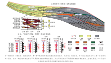
在准层序及其以上的层序地层单元内, 当包含不止一个单层时( 表 2), 相同时期、不同成因类型或不同时期、不同沉积微相的砂体相互叠置在一起, 称为复合砂体( 图 1)。一般地, 体系域(四级)内部可以划分若干个准层序(五级), 而准层序内部又可以进一步划分若干个层组(六级)。当准层序内部包含1个单层时, 则其中的砂体不属于复合砂体, 可以在单一沉积模式的指导下, 编制精细的沉积微相图来刻画单砂体分布; 而当准层序内部包含不止1个单层时, 则准层序内的砂体是不同时期不同微相砂体在垂向上及侧向上的复合, 因此, 在单一沉积模式指导下编制的沉积微相图很难刻画这一精度的地层单元。必须采用“ 复合砂体” 指导模式进行编图。当编图地层单元级别较高(如层序或体系域), 砂体数量大, 叠合方式复杂, 即使采用“ 复合砂体” 沉积模式指导编图, 也很难实现不同沉积微相砂体分布的精确表达。因此适合“ 复合砂体” 沉积模式的编图单元, 一般是准层序或准层序组( 表 2)。

表2 陆相湖盆三角洲— 滩坝“ 复合砂体” 不同级别地层单元编图对比 Table2 Comparison of mapping of delta and beach ̄bar composite sand-bodies in different grades of stratigraphic unit in continental lacustrine basin

传统的模式所建立的沉积相垂向序列主要包括三角洲反旋回序列和滩坝的反旋回或无旋回性序列等( 表 1), 单一期次的湖泊三角洲的厚度为30~70, m, 单一期次的滩坝厚度为1~10, m。然而, 无论是在现代沉积( 图 2, 图3)还是古代地层中( 图 4, 图5, 图6), 我们都发现在高频层序(数十年)发育过程中, 由于受湖浪淘洗、河流进积等因素的改造, 陆相湖盆三角洲砂体经历了沉积— 破坏— 重建的动态进积过程, 在平面上表现为后期形成的树枝状的分流河道切割早期形成的多期平行于湖岸线的滩坝砂。这种不同时期形成的不同微相砂体在空间上相互叠置、覆合, 进而形成了笔者在文中所提倡的“ 复合砂体” ( 图 1)。

图1 陆相湖盆三角洲— 滩坝“ 复合砂体” 垂向叠置样式Fig.1 Vertical superposed patterns of delta and beach ̄bar composite sand-bodies in continental lacustrine basin

3.2 三角洲— 滩坝复合砂体沉积特征

3.2.1 特征之一:现代沉积中可见晚期分流河道对早期滩坝砂体的改造 内陆湖盆湖平面的波动周期一般在数十年至数百年之间(纪友亮等, 2003, 2005; Catuneanu, 2006; Miall, 2014), 因此, 通过Google Earth和遥感可以很好地对湖岸线的迁移进行观测。笔者以青海湖和岱海现代沉积为例( 图 2), 以期对“ 复合砂体” 形成过程提供直观的证据。这2个湖盆均为中国典型的内陆封闭湖盆, 具有一定的代表性。其中青海湖面积4400, km2, 流域面积29, 660, km2, 位于东亚季风、印度季风和西风激流三者的汇聚带, 地理位置上处于中国东部季风湿润区与西北干旱区的过渡带; 岱海面积(160, km2)较小, 湖岸线长度为61.56, km, 处在内蒙古一个狭长的断陷盆地之中。
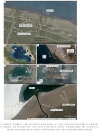
图2 青海湖、岱海现代沉积Google Earth照片Fig.2 Photos of modern sediments in Qinghai Lake and Daihai Lake by Google Earth

通过Google Earth, 可以发现青海湖的南岸和东岸都存在一种特殊的沉积相展布形态, 即在平面上可以识别多期平行于岸线展布的滩坝砂体, 被后期形成的进积型三角洲分流河道改造。在南岸( 图 2-A), 这种现象较为明显, 平面上可识别出多期滩坝砂体。在东岸( 图 2-C), 由于波浪能量和方向的差异, 导致其平面形态与南岸有所差异, 发育湾头三角洲(bayhead delta; Bhattacharya and Giosan, 2003)。岱海与青海湖具有相似性, 同样在南岸和东岸都发育这种特殊的地质现象( 图 2-E, 2-F)。由于岱海的湖域面积比青海湖小, 风的吹程小, 波浪的能量相对较弱, 因此岱海的三角洲进积作用显著(石良等, 2014)。但是, 同样可以识别出多期平行岸线的坝体被晚期进积型三角洲改造的现象。

另外, 大量气候数据显示( 图 3), 青海湖自1958年以来湖平面持续下降, 并且在每一年内的9月份水位最高(李林等, 2005; 伊万娟等, 2010)。随着湖平面的不断下降, 岸线逐渐发生迁移。遥感监测数据显示(冯钟葵和李晓辉, 2006), 1989— 2004年期间, 青海湖西岸的岸线共向湖盆中心推进约为850, m。

图3 青海湖近50年水位变化及西岸1989— 2004年岸线迁移Fig.3 Lake level changes of Qinghai Lake in recent 50 years and shore-line migrations from the year of 1989 to 2004

3.2.2 特征之二:野外露头可以识别出不同微相砂体之间相互叠置 笔者在大量的野外露头剖面上也发现了“ 复合砂体” 叠置的证据( 图 4)。川西蓬莱镇组沉积期, 地形开阔平坦, 水体较浅, 发育了一套以浅水三角洲为主的沉积体系(刘君龙等, 2015a, 2015b)。在四川盆地彭州白水河剖面出露典型的浅水三角洲露头, 通过对露头精细解剖, 共划分3期坝体和3期分流河道砂体( 图 4-A, 4-B)。在分流河道的底端发育冲刷面, 见冲刷泥砾( 图 4-C)。另外, 可见不同时期形成的坝体之间相互叠置, 不同时期形成的分流河道之间相互叠置, 并且晚期形成的分流河道CH1切割早期形成的滩坝BA3( 图 4-B, 4-D), 导致BA3顶部残缺。在青海柴达木盆地油砂山组同样可以观察到这种砂体叠置现象( 图 4-E, 4-F)。从该剖面中共识别出9期坝体和2期分流河道, 其中明显可见晚期形成的分流河道CH2对早期形成的BA4、BA5进行切割和改造。通过野外露头的精细解剖可以发现, 不同时期形成的同种微相类型之间可以相互叠置, 另外, 不同微相类型之间也可以相互叠置。而这些种砂体叠置形态, 都是“ 复合砂体” 在古代地层中最直接的证据。

图4 川西坳陷侏罗系蓬莱镇组和柴达木盆地古近系油砂山组野外露头结构要素分析Fig.4 Architecture elements analysis of outcrops of the Jurassic Penglaizhen Formation in western Sichuan Depression and the Paleogene Youshashan Formation in Qaidam Basin

3.2.3 特征之三:钻井资料可揭示“ 下残坝上河” 、“ 叠置河口坝” 等多种测井相形态 除了上述直接证据外, 笔者以川西坳陷蓬莱镇组和鄂尔多斯盆地延长组为例, 进行钻井资料解释和分析。根据高精度的测井资料( 图 5, 图6), 同样可以识别和对比“ 下残坝上河” 、“ 叠置河口坝” 等多种“ 复合砂体” 类型。

图5 川西坳陷侏罗系蓬莱镇组浅水三角洲多种成因砂体垂向叠置模式Fig.5 Superposed patterns of shallow-water deltic sand ̄bodies in the Jurassic Penglaizhen Formation in western Sichuan Depression

通过对川西坳陷400余口钻井进行沉积(微)相分析发现, 蓬莱镇组的单层砂体厚度为3~20, m。值得一提的是, 在单层厚度较大的单砂体中, 其测井曲线形态并非全部为箱型河道砂体, 也可以识别出下部反旋回上部箱型、叠置反旋回和叠置箱型等多种形态( 图 5)。其中下部反旋回上部箱型的测井相形态可以解释为“ 下残坝上河” , 如聚源21井1557.8~1563.6, m砂体、温江3井2163.1~2179.5, m砂体和丰谷22井1262.8~1273.9, m砂体等; 叠置反旋回可以解释为“ 叠置河口坝” , 如温江3井2185.1~2198.1, m砂体; 叠置箱型可以解释为“ 叠置分流河道” , 如温江3井2163.1~2173.9, m砂体。另外, 还可以在测井相上识别出晚期河口坝改造早期河道以及晚期河口坝改造早期滩坝的例子。

精细的单井沉积微相识别是沉积相研究的基础, 而连井的砂体精细对比也是尤为关键的。笔者选取鄂尔多斯盆地垂直物源走向的过罗55井— 塔19井延长组长82油层段的剖面进行砂体对比( 图 6), 同样可以识别出“ 下残坝上河” 等多种测井相形态, 如元288井在2379.2~2382.3, m和2389.8~2394.5, m的砂体, 白428井在2303.8~2308.8, m和2309.1~2315.1, m的砂体。

图6 鄂尔多斯盆地三叠系延长组罗55井— 塔19井沉积微相及砂体剖面Fig.6 Profile passing Well Luo 55 and Well Ta 19 showing sedimentary microfacies and sand-bodies in the Triassic Yanchang Formation in Ordos Basin

3.3 三角洲— 滩坝复合砂体控制因素分析

陆相湖盆三角洲— 滩坝复合砂体的形成可能受多种因素控制, 包括自旋回因素, 如河流的进积作用(Nanson, 1986; Rice, 1988; Miall, 1996; Gouw and Autin, 2008), 异旋回因素, 如构造运动(Zaleha, 1997; Hickson et al., 2005; Hampson et al., 2012; Alqahtani et al., 2015)、气候变化(Rajchl and Uli n, 2005; Hampson et al., 2012; Banham and Mountney, 2014)、基准面升降(Shanley and McCabe, 1994; Ethridge et al., 1999)和沉积物供给(Ashworth et al., 2007; Jensen and Pedersen, 2010)等。一般地, 就一个完整的源汇系统而言, 在中游和下游, 沉积体系的演化主要受海(湖)平面(近似基准面)升降控制(Hampson et al., 2012; Alqahtani et al., 2015)。笔者所讨论的陆相湖盆三角洲就是发育在中游和下游地区, 因此, 这种“ 复合砂体” 形成的控制因素主要包括水深、地形和异旋回因素, 如湖平面的升降等。

3.3.1 陆相湖盆水体较浅、地形平坦开阔 水深是影响沉积体系沉积与充填的重要因素(Galloway et al., 1975; Van Wagoner et al., 1990; Catuneanu, 2006)。在水体较浅的环境下, 湖盆三角洲会更容易地发生轴向进积和侧向迁移。陆相湖盆三角洲的形成环境与海洋相比, 一般水体较浅, 其形成的三角洲规模也较小, 如东濮凹陷古近系沙河街组发育的湖盆三角洲, 以及青海湖、岱海现代三角洲等。另外, 水体更浅的环境下(一般不大于10, m), 可以形成浅水三角洲, 这种浅水三角洲具有平面上分流河道呈树枝状, 并具有典型浅水沉积构造标志等特征, 如川西坳陷侏罗系蓬莱镇组(刘君龙等, 2015a, 2015b)、鄂尔多斯盆地三叠系延长组(邹才能等, 2008; 李元昊等, 2009)和高邮凹陷古近系阜宁组(纪友亮等, 2013)等。

除了水深, 地形对湖盆三角洲的影响也十分关键。地形的差异一般决定沉积体系自旋回过程, 而地形的陡缓在一定程度上决定了沉积体系的展布范围(Jensen and Pedersen, 2010)。笔者所讨论的湖盆三角洲多是发育在地形相对平坦、开阔的背景下, 如鄂尔多斯盆地延长组, 其地形坡度小于0.5° 。

3.3.2 湖平面频繁变化 基准面的变化对“ 湖— 陆过渡沉积体系” 具有重要的影响, 其控制着可容空间的大小, 进而决定了沉积物的充填(Shanley and McCabe, 1994)。一般地, 对于陆相湖盆三角洲、滩坝等沉积相而言, 湖平面就是近似基准面(Hampson et al., 2012; Alqahtani et al., 2015)。因此, 湖平面的升降是影响陆相湖盆三角洲— 滩坝“ 复合砂体” 形成的重要因素。陆相湖盆与海洋环境不同, 具有水体浅、体积小、能量弱等特点(解习农等, 1994; 纪友亮和张世奇, 1996)。在这样一个环境下, 湖平面的变化会相当敏感, 季节性降水、河流注入量等因素都会影响湖平面的升降, 进而影响基准面的变化。

不同级别的湖平面变化, 对湖盆内部层序充填和沉积响应有不同的影响(Shanley and McCabe, 1994; Catuneanu, 2006)。在文中, 笔者所讨论的是高频(五级层序, 对应于准层序)湖平面变化对沉积体系及岸线迁移的影响, 在油气田生产勘探中对应于砂组, 厚度为60~80, m。

依据经典层序地层学观点, 四级或者更低频的湖平面变化会控制着盆地内部的沉积体系充填和层序结构样式(Catuneanu, 2006)。然而, 在陆相湖盆中, 由于水体较浅、地形平坦, 高频湖平面变化对其影响更大。如在一个完整的湖侵体系域(四级层序)中( 图 7), 其内部可以划分5个准层序(五级层序), 而在每个准层序中, 湖平面仍然发生频繁变化, 进而导致岸线的不断迁移。在陆相湖盆中, 一个体系域一般厚度为数百米(纪友亮和张世奇, 1996), 在这样一个漫长的地质历史时期内部, 湖平面必定发生了多次的变化, 也形成了多期次的沉积体系进积和退积。如果以体系域为单元成图, 将会无法精细刻画三角洲分流河道、河口坝和滩坝等地质体, 所形成的平面图件将会出现“ 满盆含砂、相序杂乱” 的假象。当研究精度更高, 如五级层序或者更高频的层序, 由于其沉积时间相对较短, 因此, 三角洲分流河道、河口坝和滩坝等地质体将会更容易被精细刻画出来, 更能反映地质体发育规律。

图7 高频湖平面变化对沉积充填及岸线迁移的影响Fig.7 Influence of high-frequency lake level changes on sedimentary infill and shore-line migration

3.4 复合砂体分布模式的建立

笔者建立了发育在稳定构造盆地、水体较浅、地形相对平坦开阔的陆相湖盆三角洲— 滩坝复合砂体分布模式( 图 8)。该模式具有如下特征: 1)湖平面的频繁变化是“ 复合砂体” 形成的关键因素。由于陆相湖盆能量较低、水体较浅, 因此, 数米至数十米深度的湖平面波动, 都会伴随着大规模的岸线迁移。据经典层序地层学理论, 任何级别的湖平面的升降都可以近似一个完整的正弦曲线, 在正弦曲线的波峰和波谷位置, 其曲线的斜率最低, 即当湖平面上升到最高或下降到最低时, 总会存在一个湖岸线相对稳定期。在这一时期, 岸线相对固定, 进积型三角洲砂体受波浪的改造, 形成平行于岸线分布的滩坝砂体。而当湖平面发生变化时, 早期形成的坝体会受晚期分流河道进积作用的破坏, 空间上叠置形成“ 复合砂体” 。
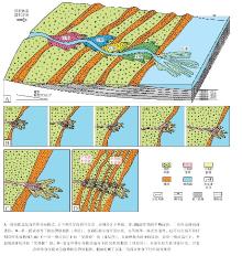
图8 陆相湖盆三角洲— 滩坝复合砂体分布模式Fig.8 Distribution pattern of the delta and beach ̄bar composite sand-bodies in continental lacustrine basin

2)三角洲分流河道、河口坝和滩坝是主要成因砂体类型。一个完整的湖平面升降过程中, 存在高水位稳定期和低水位稳定期。在这2个时期会形成2期平行于岸线分布的坝体, 分别是高水位滩坝和低水位滩坝。在湖平面快速下降过程中, 主要发育三角洲分流河道砂体。

3)晚期形成的分流河道改造早期形成的多期滩坝是该模式的主要特征。随着湖平面的下降, 三角洲向前进积, 分流河道对早期形成的坝体进行切割改造, 这种现象已经被大量现代沉积实例所证实。而在古代地层中, 则表现出多种不同时期形成的多种成因砂体相互叠置, 形成“ 下残坝上河” 、“ 叠置河口坝” 和“ 叠置分流河道” 等多种“ 复合砂体” 类型。

4 复合砂体地质编图法

古地理学是研究地质历史时期和人类历史时期自然地理特征及其演化的科学, 而古地理图是古地理学最直观的成果体现(冯增昭, 1992, 1999, 2003, 2004, 2005, 2009, 2013)。为了解决传统“ 优势相” 图无法满足生产勘探需要的难题, 笔者以陆相湖盆复合砂体分布模式为指导, 提出了一种复合砂体地质编图方法, 供各位石油地质学家参考。笔者已经在川西坳陷侏罗系和鄂尔多斯盆地陇东地区延长组沉积相研究中应用此种类型的沉积相图, 并取得了很好的实践效果, 有效地指导了勘探开发布井(图9; 刘君龙等, 2015a, 2015b)。

图9 陆相湖盆三角洲— 滩坝复合砂体沉积微相图(以川西坳陷中段侏罗系蓬莱镇组J砂组为例)Fig.9 Sedimentary microfacies map of delta and beach ̄bar composite sand-bodies in continental lacustrine basin, a case study of the J sands group of Jurassic Penglaizhen Formation in the middle part of western Sichuan Depression

这种复合砂体地质编图法是在传统单因素沉积相图编制的基础之上提出的(冯增昭, 1992, 2004), 主要针对发育在水体较浅、地形平坦开阔背景下的陆相湖盆“ 复合砂体” , 研究精度一般为包含不止一个单层的准层序, 厚度为10~100, m。以川西坳陷侏罗系蓬莱镇组为例( 图 9), 具体编图步骤如下:

1)高精度层序地层划分与对比。在精细合成地震记录基础之上, 井震结合, 对研究区蓬莱镇组地层进行精细层序地层划分和对比, 划分精度为准层序级别。

2)利用单因素法分别绘制三角洲和滩坝平面分布图。在准层序格架内部, 分别识别并且统计三角洲和滩坝的砂体厚度、砂/地比值等参数, 并绘制平面等值线图, 绘图方法参见刘君龙等(2015b)。在此基础之上, 综合钻井资料、岩心资料和地震属性等信息, 用常规沉积相分析方法, 分别绘制研究区蓬莱镇组三角洲( 图 9-A)和滩坝( 图 9-B)平面分布图。

3)对三角洲和滩坝平面分布图进行叠合。对研究区三角洲和滩坝单因素平面分布图进行垂向叠合, 完成陆相湖盆复合砂体沉积微相图的绘制( 图 9-C)。该图件主要包括以下4个要素:(1)物源方向及个数; (2)沉积相带划分及展布; (3)分流河道及河口坝— 滩坝复合砂体的平面分布特征; (4)洪水期和枯水期2条水位线。

5 结论

1)以体系域为成图单元绘制的“ 优势相” 图可以为油气田前期勘探阶段提供指导, 但是随着生产勘探实践的发展, 对沉积相的精细刻画要求日益提高, 传统单一沉积相砂体分布模式表现出了一定的局限性, 难以满足油气田需求。

2)在高频层序(数十年)发育过程中, 由于湖浪淘洗、河流进积等因素的改造, 随着岸线的不断迁移, 陆相湖盆三角洲砂体经历了沉积— 破坏— 重建的动态进积过程, 在平面上表现为后期形成的树枝状的分流河道切割早期形成的多期平行于湖岸线的滩坝砂。并且, 这种“ 复合砂体” 分布模式已经被大量现代沉积和古代地层所证实。

3)复合砂体地质编图方法是在单因素分析多因素综合作图法基础上提出的, 它以复合砂体分布模式为指导, 主要针对发育在水体较浅、地形平坦开阔背景下的陆相湖盆“ 复合砂体” , 研究精度一般为准层序, 包含物源、亚相划分、复合砂体平面分布特征和岸线分布位置等4个关键要素。

(责任编辑 李新坡)

作者声明没有竞争性利益冲突.

作者声明没有竞争性利益冲突.

参考文献
1 操应长, 韩敏, 王艳忠, 谭明友, 张营革. 2010. 济阳坳陷车镇凹陷沙二段浅水三角洲沉积特征及模式. 石油与天然气地质, 31(5): 576-582.
[Cao Y C, Han M, Wang Y Z, Tan M Y, Zhang Y G. 2010. Sedimentary characteristics and models of shallow-water delta deposits in the second member of Shahejie Formation in Chezhen Sag, the Jiyang Depression. Oil and Gas Geology, 31(5): 576-582] [文内引用:1]
2 操应长, 王健, 刘惠民, 贾光华, 万念明. 2009. 东营凹陷南坡沙四上亚段滩坝砂体的沉积特征及模式. 中国石油大学学报(自然科学版), 33(6): 5-10.
[Cao Y C, Wang J, Liu H M, Jia G H, Wan N M. 2009. Sedimentary characteristics and models of beach-bar sand bodies in the upper part of the fourth member of Paleogene in the south slope of Dongying Depression. Journal of China University of Petroleum(Edition of Natural Science), 33(6): 5-10] [文内引用:1]
3 冯增昭. 1992. 单因素分析综合作图法: 岩相古地理学方法论. 沉积学报, 10(3): 70-77.
[Feng Z Z. 1992. Single factor analysis and comprehensive mapping method: Methodology of lithofacies paleogeography. Acta Sedimentologica Sinica, 10(3): 70-77] [文内引用:2]
4 冯增昭. 1999. 中国古地理学的形成、发展与展望. 古地理学报, 1(2): 1-7.
[Feng Z Z. 1999. Origin, dvelopment and future of palaeogeography of China. Journal of Palaeogeography(Chinese Edition), 1(2): 1-7] [文内引用:1]
5 冯增昭. 2003. 中国古地理学的形成、发展、问题和共识. 古地理学报, 5(2): 129-141.
[Feng Z Z. 2003. Origin, development, problems and common viewpoint of palaeogeography of China. Journal of Palaeogeography(Chinese Edition), 5(2): 129-141] [文内引用:1]
6 冯增昭. 2004. 单因素分析多因素综合作图法: 定量岩相古地理重建. 古地理学报, 6(1): 3-19.
[Feng Z Z. 2004. Single factor analysis and multifactor comprehensive mapping method: Reconstruction of quantitative lithofacies palaeogeography. Journal of Palaeogeography(Chinese Edition), 6(1): 3-19] [文内引用:1]
7 冯增昭. 2005. 从定量岩相古地理学谈华南地区海相地层油气勘探. 古地理学报, 7(1): 1-11.
[Feng Z Z. 2005. Discussion on petroleum exploration of marine strata in South China from quantitative lithofacies palaeogeography. Journal of Palaeogeography(Chinese Edition), 7(1): 1-11] [文内引用:1]
8 冯增昭. 2009. 中国古地理学的定义、内容、特点和亮点. 古地理学报, 11(1): 1-11.
[Feng Z Z. 2009. Definition, content, characteristics and bright spots of palaeogeography of China. Journal of Palaeogeography(Chinese Edition), 11(1): 1-11] [文内引用:1]
9 冯增昭. 2013. 中国沉积学(第二版). 北京: 石油工业出版社, 743-746.
[Feng Z Z. 2013. Sedimentology of China(Second Edition). Beijing: Petroleum Industry Press, 743-746] [文内引用:2]
10 冯钟葵, 李晓辉. 2006. 青海湖近20年水域变化及湖岸演变遥感监测研究. 古地理学报, 8(1): 131-141.
[Feng Z K, Li X H. 2006. Remote sensing monitoring study for water area change and Lakeshore evolution of Qinghai Lake in last 20 years. Journal of Palaeogeography(Chinese Edition), 8(1): 131-141] [文内引用:1]
11 胡明毅, 马艳荣, 刘仙晴, 王辉, 王延奇. 2009. 大型坳陷型湖盆浅水三角洲沉积特征及沉积相模式: 以松辽盆地茂兴—敖南地区泉四段为例. 石油天然气学报, 31(3): 13-17.
[Hu M Y, Ma Y R, Liu X Q, Wang H, Wang Y Q. 2009. Sedimentary characteristics and mode of shallow delta in large scale downwrap lacustrine basin: By taking Quan-4 Formation in Maoxing and Aonan region in Songliao Basin for example. Journal of Oil and Gas Technology, 31(3): 13-17] [文内引用:1]
12 胡受权, 颜其彬. 1998. 泌阳断陷双河—赵凹地区陆相层序地层学模式. 地质科学, 33(4): 54-62.
[Hu S Q, Yan Q B. 1998. Sequence stratigraphic model in Shuanghe-Zhaoao of Biyang Fault-Depression, Henan Province. Chinese Journal of Geology(Scientia Geologica Sinica), 33(4): 54-62] [文内引用:1]
13 纪友亮, 张世奇. 1996. 陆相断陷湖盆层序地层学. 北京: 石油工业出版社.
[Ji Y L, Zhang S Q. 1996. The Sequence Stratigraphy of Terrestrial Rift Lacustrine Basin. Beijing: Petroleum Industry Press] [文内引用:3]
14 纪友亮, 冯建辉, 王声朗, 张宏安, 王德仁. 2003. 东濮凹陷沙三段高频湖平面变化及低位砂体预测. 高校地质学报, 9(1): 99-112.
[Ji Y L, Feng J H, Wang S L, Zhang H A, Wang D R. 2003. High Frequency lake-level change of 3rd Member of Shahejie Formation and prediction of lowstand sand body in Dongpu Depression. Geological Journal of China Universities, 9(1): 99-112] [文内引用:1]
15 纪友亮, 冯建辉, 王声朗, 张宏安, 王德仁. 2005. 东濮凹陷古近系沙河街组沙三段沉积期湖岸线的变化及岩相古地理特征. 古地理学报, 7(2): 145-156.
[Ji Y L, Feng J H, Wang S L, Zhang H A, Wang D R. 2005. Shifting of lake shoreline and lithofacies palaeogeographic characters during sedimentary period of the Member 3 of Shahejie Formation of Paleogene in Dongpu Sag. Journal of Palaeogeography(Chinese Edition), 7(2): 145-156] [文内引用:1]
16 纪友亮, 卢欢, 刘玉瑞. 2013. 苏北盆地高邮凹陷古近系阜宁组一段浅水三角洲和滩坝沉积模式. 古地理学报, 15(5): 729-740.
[Ji Y L, Lu H, Liu Y R. 2013. Sedimentary model of shallow water delta and beach bar in the Member 1 of Paleogene Funing Formation in Gaoyou sag, Subei Basin. Journal of Palaeogeography(Chinese Edition), 15(5): 729-740] [文内引用:2]
17 姜在兴, 王俊辉, 张元福. 2015. 滩坝沉积研究进展综述. 古地理学报, 17(4): 427-440.
[Jiang Z X, Wang J H, Zhang Y F. 2015. Advances in beach-bar research: A review. Journal of Palaeogeography(Chinese Edition), 17(4): 427-440] [文内引用:1]
18 金振奎, 高白水, 李桂仔, 刁丽颖, 闫伟, 李燕, 张淼. 2014. 三角洲沉积模式存在的问题与讨论. 古地理学报, 16(5): 569-580.
[Jin Z K, Gao B S, Li G Z, Diao L Y, Yan W, Li Y, Zhang M. 2014. Problems and discussions about delta depositional models. Journal of Palaeogeography(Chinese Edition), 16(5): 569-580] [文内引用:1]
19 李林, 朱西德, 王振宇, 汪青春. 2005. 近42 a来青海湖水位变化的影响因子及其趋势预测. 中国沙漠, 25(5): 689-696.
[Li L, Zhu X D, Wang Z Y, Wang Q C. 2005. Impacting factors and changing tendency of water level in Qinghai Lake in recent 42 years. Journal of Desert Research, 25(5): 689-696] [文内引用:1]
20 李元昊, 刘池洋, 独育国, 王秀娟, 黄锦绣. 2009. 鄂尔多斯盆地西北部上三叠统延长组长8油层组浅水三角洲沉积特征及湖岸线控砂. 古地理学报, 11(3): 265-274.
[Li Y H, Liu C Y, Du Y G, Wang X J, Huang J X. 2009. Sedimentary characteristics of shallow water delta and lake shoreline control on sand bodies of Chang 8 oil-bearing interval of the Upper Triassic Yanchang Formation in northwestern Ordos Basin. Journal of Palaeogeography(Chinese Edition), 11(3): 265-274] [文内引用:3]
21 林畅松. 2009. 沉积盆地的层序和沉积充填结构及过程响应. 沉积学报, 27(5): 849-862.
[Lin C S. 2009. Sequence and depositional architecture of sedimentary basin and process responses. Acta Sedimentologica Sinica, 27(5): 849-862] [文内引用:1]
22 林畅松, 刘景彦, 刘丽军, 张韬, 李喜臣. 2002. 高精度层序地层分析: 建立沉积相和储集层规模的等时地层格架. 现代地质, 16(3): 276-281.
[Lin C S, Liu J Y, Liu L J, Zhang T, Li X C. 2002. High resolution sequence stratigraphy analysis: Construction of chronostratigraphic sequence framework on facies and reservoir scale. Geoscience, 16(3): 276-281] [文内引用:1]
23 刘君龙, 纪友亮, 杨克明, 周勇, 陈贤良, 高崇龙, 贾浪波. 2015 a. 浅水湖盆三角洲岸线控砂机理与油气勘探意义: 以川西坳陷中段蓬莱镇组为例. 石油学报, 36(9): 1060-1073.
[Liu J L, Ji Y L, Yang K M, Zhou Y, Chen X L, Gao C L, Jia L B. 2015 a. Mechanism of lake shoreline control on shoal water deltic sand bodies and its significance for petroleum exploration: A case study of Penglaizhen Formation in the middle part of western Sichuan depression. Acta Petrolei Sinica, 36(9): 1060-1073] [文内引用:1]
24 刘君龙, 杨克明, 纪友亮, 朱宏权, 黄富祥, 贾浪波. 2015 b. 川西坳陷上侏罗统浅水漫湖沉积特征与砂体叠置模式. 古地理学报, 17(4): 503-516.
[Liu J L, Yang K M, Ji Y L, Zhu H Q, Huang F X, Jia L B. 2015 b. Sedimentary characteristics and sand -body superposed patterns of flood-overlake deposits of the Upper Jurassic in Chuanxi Depression. Journal of Palaeogeography(Chinese Edition), 17(4): 503-516] [文内引用:1]
25 楼章华, 卢庆梅, 蔡希源, 董百万, 张立庆. 1998. 湖平面升降对浅水三角洲前缘砂体形态的影响. 沉积学报, 16(4): 27-31.
[Lou Z H, Lu Q M, Cai X Y, Dong B W, Zhang L Q. 1998. Influence of lake fluctuation on sand body shapes at shallow-water delta front. Acta Sedimentologica Sinica, 16(4): 27-31] [文内引用:1]
26 裘亦楠, 肖敬修, 薛培华. 1982. 湖盆三角洲分类的探讨. 石油勘探与开发, (1): 1-11.
[Qiu Y N, Xiao J X, Xue P H. 1982. Discussion on category of lake deltas. Petroleum Exploration and Development, (1): 1-11] [文内引用:1]
27 石良, 金振奎, 李桂仔, 高白水, 闫伟. 2014. 内蒙古岱海现代辫状河三角洲沉积特征及沉积模式. 天然气工业, 34(9): 33-39.
[Shi L, Jin Z K, Li G Z, Gao B S, Yan W. 2014. Depositional characteristics and models of the modern braided river delta in the Daihai Lake, Inner Mongolia. Natural Gas Industry, 34(9): 33-39] [文内引用:1]
28 吴崇筠. 1983. 构造湖盆三角洲与油气分布. 沉积学报, 1(1): 5-26.
[Wu C Y. 1983. Structural lake deltas and oil-gas distribution. Acta Sedimentologica Sinica, 1(1): 5-26] [文内引用:1]
29 解习农, 李思田, 高东升, 葛立刚, 龚绍礼. 1994. 江西丰城矿区障壁坝砂体内部构成及沉积模式. 岩相古地理, 14(4): 1-10.
[Xie X N, Li S T, Gao D S, Ge L G, Gong S L. 1994. Architectural elements and sedimentray model for barrier sand bodies in the Gengcheng mining district, Jiangxi. Sedimentary Facies and Palaeogeography, 14(4): 1-10] [文内引用:2]
30 伊万娟, 李小雁, 崔步礼, 马育军. 2010. 青海湖流域气候变化及其对湖水位的影响. 干旱气象, 28(4): 375-383.
[Yi W J, Li X Y, Cui B L, Ma Y J. 2010. Climate change and impact on water level of the Qinghai Lake Watershed. Journal of Arid Meteorology, 28(4): 375-383] [文内引用:1]
31 于兴河, 李胜利, 李顺利. 2013. 三角洲沉积的结构: 成因分类与编图方法. 沉积学报, 31(5): 782-797.
[Yu X H, Li S L, Li S L. 2013. Texture-genetic classifications and mapping methods for deltaic deposits. Acta Sedimentologica Sinica, 31(5): 782-797] [文内引用:2]
32 郑荣才, 王海红, 韩永林, 王成玉, 牛小兵, 王昌勇. 2008. 鄂尔多斯盆地姬塬地区长6段沉积相特征和砂体展布. 岩性油气藏, 20(3): 21-26.
[Zheng R C, Wang H H, Han Y L, Wang C Y, Niu X B, Wang C Y. 2008. Sedimentary facies characteristics and sand body distribution of Chang 6, member in Jiyang area of Ordos Basin. Lithologic Reservoirs, 20(3): 21-26] [文内引用:1]
33 朱筱敏. 2008. 沉积岩石学(第四版). 北京: 石油工业出版社, 296-316.
[Zhu X M. 2008. Sedimentary Petrology(Forth Edition). Beijing: Petroleum Industry Press, 296-316] [文内引用:1]
34 朱筱敏, 刘媛, 方庆, 李洋, 刘云燕, 王瑞, 宋静, 刘诗奇, 曹海涛, 刘相男. 2012. 大型坳陷湖盆浅水三角洲形成条件和沉积模式: 以松辽盆地三肇凹陷扶余油层为例. 地学前缘, 19(1): 89-99.
[Zhu X M, Liu Y, Fang Q, Li Y, Liu Y Y, Wang R, Song J, Liu S Q, Cao H T, Liu X N. 2012. Formation and sedimentary model of shallow delta in large-scale lake, example from Cretaceous Quantou Formation in Sanzhao sag, Songliao Basin. Earth Science Frontiers, 19(1): 89-99] [文内引用:1]
35 朱筱敏, 潘荣, 赵东娜, 刘芬, 吴冬, 李洋, 王瑞. 2013. 湖盆浅水三角洲形成发育与实例分析. 中国石油大学学报(自然科学版), 37(5): 7-14.
[Zhu X M, Pan R, Zhao D N, Liu F, Wu D, Li Y, Wang R. 2013. Formation and development of shallow-water deltas in lacustrine basin and typical case analyses. Journal of China University of Petroleum(Edition of Natural Science), 37(5): 7-14] [文内引用:1]
36 朱筱敏, 信荃麟, 张晋仁. 1994. 断陷湖盆滩坝储集体沉积特征及沉积模式. 沉积学报, 12(2): 20-28.
[Zhu X M, Xin Q L, Zhang J R. 1994. Sedimentary characteristics and models of the beach-bar reservoirs in faulted down lacustrine basins. Acta Sedimentologica Sinica, 12(2): 20-28] [文内引用:4]
37 邹才能, 赵文智, 张兴阳, 罗平, 王岚, 刘柳红, 薛叔浩, 袁选俊, 朱如凯, 陶士振. 2008. 大型敞流坳陷湖盆浅水三角洲与湖盆中心砂体的形成与分布. 地质学报, 82(6): 813-825.
[Zou C N, Zhao W Z, Zhang X Y, Luo P, Wang L, Liu L H, Xue S H, Yuan X J, Zhu R K. 2008. Formation and distribution of shallow-water deltas and central-basin sand bodies in large open depression lake basins. Acta Geologica Sinica, 82(6): 813-825] [文内引用:1]
38 Alqahtani F A, Johnson H D, Jackson C A, Som M R B. 2015. Nature, origin and evolution of a Late Pleistocene incised valley-fill, Sunda Shelf, Southeast Asia. Sedimentology, 62: 1198-1232. [文内引用:3]
39 Ambrose W A, Hentz T F, Bonnaffé F, Loucks R G, Brown L F J R, Wang F P, Potter E C. 2009. Sequence-stratigraphic controls on complex reservoir architecture of highstand fluvial-dominated deltaic and lowstand valley-fill deposits in the Upper Cretaceous(Cenomanian)Woodbine Group, East Texas field: Regional and local perspectives. AAPG Bulletin, 93(2): 231-269. [文内引用:1]
40 Ashworth P J, Best J L, Jones M A. 2007. The relationship between channel avulsion, flow occupancy and aggradation in braided rivers: Insights from an experimental model. Sedimentology, 54: 497-513. [文内引用:1]
41 Ayers W B. 1986. Lacustrine and fluvial-deltaic depositional systems, Fort Union Formation(Paleocene), Powder River Basin, Wyoming and Montana. AAPG Bulletin, 70: 1651-1673. [文内引用:1]
42 Banham S G, Mountney N P. 2014. Climatic versus halokinetic control on sedimentation in a dryland fluvial succession. Sedimentology, 61: 570-608. [文内引用:1]
43 Bhattacharya J P. 2011. Practical problems in the application of the sequence stratigraphic method and key surfaces: Integrating observations from ancient fluvial-deltaic wedges with Quaternary and modelling studies. Sedimentology, 58(1): 120-169. [文内引用:1]
44 Bhattacharya J P, Giosan L. 2003. Wave-influenced deltas: Geomorphological implications for facies reconstruction. Sedimentology, 50(1): 187-210. [文内引用:1]
45 Buatois L A, Santiago N, Herrera M, Plink-björklund P, Steel R, Espin M, Parra K. 2012. Sedimentological and ichnological signatures of changes in wave, river and tidal influence along a Neogene tropical deltaic shoreline. Sedimentology, 59(5): 1568-1612. [文内引用:1]
46 Catuneanu O. 2006. Principles of sequence stratigraphy. Amsterdam: Elsevier, 375. [文内引用:4]
47 Chan M A, Dott R H. 1986. Depositional Facies and Progradational Sequences in Eocene Wave-Dominated Deltaic Complexes, Southwestern Oregon. AAPG Bulletin, 70: 415-429. [文内引用:1]
48 Coleman J M, Prior D B. 1982. Deltaic environments of deposition. In: Scholle P A, Sprarlng D(eds). Sand stone Depositional Envi-ronments. AAPG Memoir. Tulsa, Okla: American Association of Petroleum Geologists, 31: 139-178. [文内引用:1]
49 Donaldon A C. 1974. Pennsylvanian sedimentation of central Appalalachians. Special Paperof Geology Society of America, 148: 47-78. [文内引用:1]
50 Ethridge F G, Skelly R L, Bristow C S. 1999. Avulsion and crevassing in the sand y, braided Niobrara River: Complex response to base-level rise and aggradation. In: Smith N D, Rogers J (eds). Fluvial Sedimentology Ⅵ. International Association of Sedimentologists Special Publication, 28: 179-191. [文内引用:1]
51 Fisher W L, Mcgowen J H. 1969. Depositional systems of the Wilcox Group(Eocene)of Texas and their relationship to occurrence of oil and gas. AAPG Bulletin, 53: 30-54. [文内引用:1]
52 Galloway W E. 1975. Process framework for describing the morphologic and stratigraphic evolution of deltaic depositional systems. Houston Geological Society: 87-98. [文内引用:4]
53 Gouw M J P, Autin W J. 2008. Alluvial architecture of the Holocene Lower Mississippi Valley(U. S. A. )and a comparison with the Rhine-Meuse delta(The Netherland s). Sedimentary Geology, 204: 106-121. [文内引用:1]
54 Hampson G J, Royhan G M, Sahoo H, Rittersbacher A, Irfan N, Ranson A, Jewell T O, Gani N D S, Howell J A, Buckley S J, Bracken B. 2012. Controls on large-scale patterns of fluvial sand body distribution in alluvial to coastal plain strata: Upper Cretaceous Blackhawk Formation, Wasatch Plateau, Central Utah, USA. Sedimentology, 59: 2226-2258. [文内引用:4]
55 Hickson T A, Sheets B A, Paola C, Kelberer M. 2005. Experimental test of tectonic controls on three-dimensional alluvial facies architecture. Journal of Sedimentary Research, 75: 710-722. [文内引用:1]
56 Jensen M A, Pedersen G K. 2010. Architecture of vertically stacked fluvial deposits, Atane Formation, Cretaceous, Nuussuaq, central West Greenland . Sedimentology, 57: 1280-1314. [文内引用:2]
57 Jerolmack D J, Swenson J B. 2007. Scaling relationships and evolution of distributary networks on wave-influenced deltas. Geophysical Research Letters, 34(23): 1-5. [文内引用:1]
58 Larue D K, Legarre H. 2004. Flow units, connectivity, and reservoir characterization in a wave-dominated deltaic reservoir: Meren reservoir, Nigeria. AAPG Bulletin, 88(3): 303-324. [文内引用:1]
59 Lemons D R, Chan M A. 1999. Facies architecture and sequence stratigraphy of fine-grained lacustrine deltas along the eastern margin of Late Pleistocene lake Bonneville, Northern Utah and Southern Idaho. AAPG Bulletin, 83: 635-665. [文内引用:1]
60 Miall A D. 1996. The Geology of Fluvial Deposits: Sedimentary Facies, Basin Analysis, and Petroleum Geology. Springer: 582. [文内引用:1]
61 Miall A D. 2014. Fluvial Depositional Systems. Springer: 322. [文内引用:2]
62 Nanson G C. 1986. Episodes of vertical accretion and catastrophic stripping: A model of disequilibrium floodplain development. Geological Society of America Bulletin, 97: 1467-1475. [文内引用:1]
63 Olariu C, Bhattacharya J P. 2006. Terminal Distributary Channels and Delta Front Architecture of River-Dominated Delta Systems. Journal of Sedimentary Research, 76(2): 212-233. [文内引用:1]
64 Orton G J. 1988. A Spectrum of Middle Ordovician Fan-deltas and Braid Plain Deltas, North Wales: A Consequence of Varying Fluvial Clastic Input. In: Nemec W, Steel R J(eds). Fan Deltas: Sedimentology and Tectonic Settings . Glasgow: Blackie, 23-49. [文内引用:2]
65 Postma G. 1990. An analysis of the variation in delta architecture. Terra Nova, 2: 124-130. [文内引用:4]
66 Rajchl M, Ulicny D. 2005. Depositional record of an avulsive fluvial system controlled by peat compaction(Neogene, Most Basin, Czech Republic). Sedimentology, 52: 601-625. [文内引用:1]
67 Rice R J. 1988. Fundamentals of geomorphology. London: Longman, 420. [文内引用:1]
68 Scholz C A. 1995. Deltas of the Lake Malawi Rift, East Africa: Seismic expression and exploration implications. AAPG Bulletin, 79: 1679-1697. [文内引用:1]
69 Shanley K W, McCabe P J. 1994. Perspectives on the sequence stratigraphy of continental strata. AAPG Bulletin, 78: 544-568. [文内引用:3]
70 UliČný D. 2001. Depositional systems and sequence stratigraphy of coarse-grained deltas in a shallow-marine, strike-slip setting: The Bohemian Cretaceous Basin, Czech Republic. Sedimentology, 48(3): 599-628. [文内引用:1]
71 Van Wagoner J C, Mitchun R M, Campion K M, Rahmanian V D. 1990. Siliciclastic sequence stratigraphy in well, core and outcrops and outcrops-concept for high-resolution correlation of times and facies. AAPG Methods Explor. Ser. , 7: 1-55. [文内引用:1]
72 Whitbread T, Kelling G. 1982. Mrar Formation of Western Libya: Evolution of an Early Carboniferous delta system. AAPG Bulletin, 66: 1091-1107. [文内引用:1]
73 Zaleha M J. 1997. Intra-and extrabasinal controls on fluvial deposition in the Miocene Indo-Gangetic foreland basin, northern Pakistan. Sedimentology, 44: 369-390. [文内引用:1]