祁连山东段童子坝河阶地对气候变化与新构造运动的响应*
钟岳志1, 李有利1, 熊建国1,2, 雷惊昊1, 辛伟林1, 胡秀1, 刘飞1
1 北京大学城市与环境学院,北京 100871
2 中山大学地球科学与工程学院,广东广州 510275

第一作者简介 钟岳志,男, 1992年生,北京大学城市与环境学院硕士研究生,研究方向为构造地貌学。 E-mail: 1401214641@pku.edu.cn

通讯作者简介 李有利,男, 1965年生,北京大学城市与环境学院教授,主要从事构造地貌学与环境演变研究。 E-mail: liyouli@pku.edu.cn

摘要

通过对祁连山东段童子坝河各级阶地的年代和变形程度进行测定,得到了河流阶地的形成年代和过程,推算出民乐—大马营逆断裂的活动强度和速率,并分析了阶地形成和气候变化之间的关系。童子坝河 5级阶地(年龄分别为 16.70±1.81 cal, ka BP 10 092.5±27.5 cal a BP 8127.5±72.5 cal a BP 2900±60 cal a BP 282.5±17.5 cal a BP)均形成于气候由冷转暖的阶段,属于气候成因阶地。基于断裂两侧阶地面的平面几何形态并结合上、下盘阶地横剖面同级阶地的高差,得到 T4 T3 T2 T1阶地在民乐—大马营断裂处的垂直位错分别为 10.6±3.1, m 5.0±2.6 m 2.0±1.9 m 1.9±1.3 m,推算出全新世以来民乐—大马营断裂的垂直滑动速率为 1.05±0.31 mm/a,水平缩短速率为 1.02±0.60 mm/a

关键词: 河流阶地; 构造地貌; 气候变化; 祁连山
中图分类号:P512.2 文献标志码:A 文章编号:1671-1505(2017)06-1075-12
Terraces of the Tongziba River, eastern Qilian Mountain and their responses to neotectonic movement and climate change
Zhong Yuezhi1, Li Youli1, Xiong Jianguo1,2, Lei Jinghao1, Xin Weilin1, Hu Xiu1, Liu Fei1
1 College of Urban and Environmental Science,Peking University,Beijing 100871
2 School of Earth Science and Geological Engineering,Sun Yat-sen University,Guangzhou 510275,Guangdong

About the first author Zhong Yuezhi,born in 1992,is a master degree candidate of Peking University. His research area is tectonic geomorphology. E-mail: 1401214641@pku.edu.cn.

About the corresponding author Li Youli,born in 1965,is a professor of Peking University. He is mainly engaged in tectonic geomorphology and environmental evolution. E-mail: liyouli@pku.edu.cn.

Abstract

Based on fluvial terraces dating and deformation determination,the formation age and processes of river terraces of the Tongziba River,eastern Qilian Mountain are obtained. The activity intensity and rate of the Minle-Damaying thrusting fault are calculated and the relationship between the formation of terraces and climate change is analyzed. Dating results in comparison with climate curves or events indicate the five fluvial terraces with ages of 16.70±1.81cal ka BP,10 092.5±27.5 cal a BP,8127.5±72.5 cal a BP,2900±60 cal a BP and 282.5±17.5 cal a BP,formed during the transition from warm to cold climate. Based on the plane geometry of fluvial terraces on both sides of the Minle-Damaying fault as well as height differences between the same level terraces located in hanging wall and footwall,vertical offsets of T4-T1 were estimated to be 10.6±3.1 m,5.0±2.6 m,2.0±1.9 m and 1.9±1.3 m,respectively. By integrating the various research results,it is concluded that the vertical slip rate of the Minle-Damaying fault was 1.05±0.31 mm/a and horizontal shortening rate 1.02±0.60 mm/a since the Holocene.

Key words: fluvial terrace; tectonic geomorphology; climate change; Qilian Mountain
1 概述

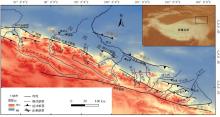
自新生代以来, 印度板块向北俯冲与欧亚板块的持续碰撞造成以青藏高原为代表的巨大高原的强烈隆升, 是地质历史上的重大事件(Molnar et al., 1993; Yin and Harrison, 2000)。平均海拔超过4000, m的青藏高原不仅极大地改变了自身及其周边区域的地貌与自然环境, 同时对全球气候变化也有重要影响(An et al., 2001; Kent and Muttoni, 2008; Liu and Dong, 2013)。然而, 对于印度板块与欧亚板块碰撞发生的时间、方式以及青藏高原隆升历史仍存在争议(Patriat and Achache, 1894; Molnar et al., 1993; Clark and Royden, 2000; Li et al., 2014)。同时, 分析亚洲内部干旱的驱动因素也一直是研究热点(Mé tivier et al., 1998; An et al., 2001; Heermance et al., 2007; Xiao et al., 2012)。

位于青藏高原东北边缘的祁连山(图 1)受青藏高原向北挤压和变形的影响, 是中国西北活动构造变形特征最敏感、构造活动和地震运动最强烈的地区之一(Tapponniner et al., 1990; Hetzel et al., 2004; Chen et al., 2008; Zheng et al., 2010; 金卿等, 2011)。祁连山的抬升形成了众多层状地貌, 典型的有夷平面及河流阶地, 能很好地反映青藏高原阶段性隆升和不断向北扩展的活动历史(李有利和杨景春, 1997; 潘保田等, 2000, 2004)。影响阶地发育的因素主要有构造活动、气候变化和侵蚀基准面变化, 而侵蚀基准面的变化是构造运动或气候变化引起的, 因而构造活动和气候变化一般是影响河流阶地发育的主要因素(Starkel, 2003)。同时, 河流阶地对构造活动和气候变化的响应十分灵敏, 使其成为研究河流地貌演化与断层活动或者气候变化关系的理想载体(Pan et al., 2013; Zheng et al., 2013; Lu et al., 2014)。

作者以祁连山东段童子坝河河流阶地为研究对象(图 1), 在比较系统的野外调查和文献调研的基础上, 记录童子坝河河流阶地的级数、空间分布、拔河高度等参数, 进行河谷有代表性的横剖面和纵剖面的绘制, 同时对各级河流阶地的年龄进行测定, 首先建立了童子坝河河流阶地的年代序列, 进一步分析了阶地的形成原因和环境意义, 并对该区域对新构造运动和气候变化的响应进行分析讨论。

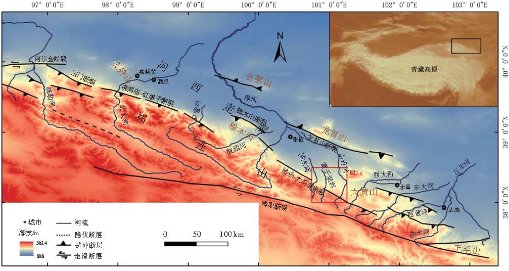
图 1 祁连山东段构造背景与童子坝河位置Fig.1 Tectonic setting of eastern Qilian Mountain and location of the Tongziba River

2 研究区概况
2.1 地质背景

祁连山为典型多旋回加里东运动槽, 在中国的大地构造划分中, 祁连山属于祁连褶皱系。按地质发育特征可以将地槽褶皱系从北向南划分为若干个构造单元。其中, 走廊过渡带为压陷盆地, 一些近南北向的断裂发育在盆地内部并形成了3个次级隆起, 自西北向东南分别为文殊山隆起、榆木山隆起(Tapponnier et al., 1990)、大黄山隆起, 3个隆起将河西走廊盆地细分为若干个次级盆地, 构成了河西走廊盆地的主要地貌单元(Li and Yang, 1998)。

位于北祁连山褶皱带和走廊过渡带之间的祁连山北缘断裂全长约860, km, 可达数千米深, 平面上自西往东呈 NWW 向左阶斜列展布包括民乐— 大马营断裂在内的一系列断裂(图1)。前人对晚更新世— 全新世以来的祁连山北缘断裂的垂直滑动速率进行了研究, 旱峡— 大黄沟断裂约为0.25, mm/a(Zheng et al., 2013)、玉门断裂为0.18~0.25, mm/a(闵伟等, 2002)、佛洞庙— 红崖子断裂的西段和中段分别约为1.6, mm/a和1.3, mm/a(杨海波, 2016)、榆木山断裂为0.5~0.8, mm/a(Palumbo et al., 2009; 郑文俊, 2009; Seong et al., 2011)、张掖逆断裂垂直滑动速率为0.6~0.9, mm/a, 水平缩短速率为0.4~1.1, mm/a(Hetzel et al., 2004)。在空间分布特征上, 祁连山北缘断裂带晚更新世以来的运动学速率展现出祁连山山体抬升速率中间大、两端小的特点(胡小飞等, 2010; Palumbo et al., 2011)。Li 和 Yang(1998)根据源自祁连山的最新一期洪积扇已堆积至盆地中部认为祁连山北缘断裂前锋带已经向北扩展至河西走廊盆地中部, 而最新的地震反射剖面也证实了这一观点(Zuza et al., 2016)。

民乐— 大马营断裂沿祁连山北麓展布, 全长约200, km(图1)。断裂可进一步划分为多条大体平行的逆冲断裂。断层上盘为古近系和新近系砂砾岩、砂质泥岩; 下盘为第四系中更新统砾卵石层, 断层在洪水河口、小堵麻河口等地出露(刘兴春, 2000)。断裂呈叠瓦式逆冲, 有少量陡坎分布于马营河以西的老洪积扇上, 但在全新世洪积扇未发现陡坎(中国地震局地质研究所, 1993)。同时根据童子坝河T1阶地没有发生构造变形, 前人认为民乐— 大马营断裂仅在晚更新世有活动, 而全新世以来活动并不明显(中国地震局兰州地震研究所, 2000)。

2.2 气候背景

前人的研究认为河西走廊西段主要受西风带控制, 而河西走廊东段可受亚洲夏季风的影响(王岳, 2016)。张掖盆地位于河西走廊中段的气候过渡带, 属于温带大陆性气候, 夏季日照时间长、太阳辐射强烈、昼夜温差较大、降水稀少而集中、蒸发较为强烈。年均气温7.2, ℃; 年均降水量为128~500, mm, 且由东南向西北逐渐递减; 年均水面蒸发量约为2000, mm, 从东南向西北方向递增; 降水多集中在6~9月份之间, 占全年总降水量的70%~80%。由于蒸发量远大于降水量, 张掖盆地的水资源几乎依赖于祁连山区降水与冰雪融水的补给。区内河流主要有黑河、梨园河、洪水河、大堵麻河等12条河流, 其中黑河地表径流量最大, 贯穿甘州、临泽和高台三区县, 其他河流大多数源近流短, 出山后消失在冲、洪积扇附近。

李育等(2013)对走廊中段的盐池湖泊沉积记录进行了分析, 发现全新世以来该区气候与季风区相似性极高, 而与西风区存在差异, 并进一步认为该区位于千年尺度亚洲夏季风北部边界摆动带上。吴永红等(2006)对扁都口黄土剖面的粒度、磁化率、碳酸钙和色度等指标进行分析, 认为走廊中部全新世大暖期持续时间为9000 — 2200 a BP, 并在8000— 6200 a BP、5600— 4300 a BP和3000— 2200 a BP为明显的温暖期。韩金(2016)对童子坝河附近的冰沟台和董家庄黄土剖面的粒度和磁化率指标进行分析后, 发现民乐地区在12 000 a BP出现了暖事件, 降水增多, 认为是对波令— 阿勒罗德暖期(B/A)(Stuvier et al., 1995)的响应, 并认为温度随后开始急剧降低, 到10, 220 a BP时温度最低, 并将剖面中对应位置和玉带河一带地层中发现的黑色条带归因于气候干旱造成的森林火灾。此外, 认为全新世大暖期在10, 220— 3267 a BP之间。

3 童子坝河阶地特征
3.1 阶地序列及沿程分布

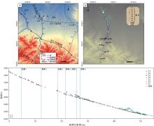
依据野外勘查, 沿童子坝河至少有7级阶地发育, T1年代最新, T7年代最老(图 2)。

图 2 祁连山东段童子坝河阶地分布与纵剖面
a— 研究区地形、主要河流与断裂; b— 沿童子坝河阶地与河床GPS测量点; c— 童子坝河阶地与现代河床纵剖面
Fig.2 Terrace distribution and longitudinal profiles along the Tongziba River, eastern Qilian Mountain

T1— T4级阶地沿童子坝河广泛分布, 为本研究主要讨论的阶地(图 2)。河流出山口以上这4级阶地的地貌参数如表1所示。

河流出山后, T1— T4阶地均过渡为埋藏基座阶地, 砾石层拔河高度逐步降低, 其中T1、T2和T3阶地分别在距河流源头约32, km、35, km和37, km处消失, 埋藏于地下。T4阶地在距河流源头约39, km处拔河高度仅1, m左右, 在距源头约40, km处, T4级阶地由于受永固背斜隆起的影响, 虽仍为埋藏基座阶地, 但拔河高度开始增加, 至距河流源头约45, km处的背斜核部区域拔河高度达到20, m左右; 跨过背斜核部之后, T4阶地拔河高度随背斜的降低也逐步降低, 至距河流源头约51, km处拔河高度下降至1, m左右。

T5阶地主要分布于童子坝河出山口附近, 为基座阶地, 砾石层拔河高度最高可达80, m左右。T6和T7阶地主要分布于永固背斜处, 均为基座阶地, 其中T6阶地砾石层最高拔河达60, m左右, T7阶地砾石层最高拔河可达90, m以上。

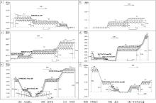
野外实测了一系列童子坝河横剖面, 文中列举6个典型横剖面来对阶地的结构特征进行论述(图 3), 剖面空间位置见图2-b。

图 3 祁连山东段童子坝河典型的展现阶地分布的河流横剖面
a— 剖面1; b— 剖面2; c— 剖面3; d— 剖面4; e— 剖面5; f— 剖面6。剖面位置见图2-b
Fig.3 Typical cross sections showing the distribution of terraces along the Tongziba River, eastern Qilian Mountain

剖面1位于距河流源头约5, km处(图 3-a), 该处T1、T2和T3级阶地均为基座阶地。阶地砾石较粗大, 粒径10~50, cm, 分选一般。T3阶地砾石层高出现代河床10, m左右; 砾石层之上堆积20, cm左右河漫滩相砂层, 上覆约2, m厚的黄土。

表 1 祁连山东段童子坝河阶地的地貌参数 Table1 Geomorphic parameters of terraces of the Tongziba River, eastern Qilian Mountain

剖面2位于距河流源头约12, km处(图 3-b), 阶地砾石也比较粗大, 粒径基本在10~60, cm之间, 分选一般。T2阶地砾石层高出现代河床8, m左右; 之上堆积10, cm左右的河漫滩相砂层, 有厚50, cm左右的黄土覆盖在砂层之上。

剖面3位于距河流源头约19, km处(图 3-c), 此处T1阶地为埋藏基座阶地, 砾石层拔河2.9, m, 未见底; 砾石磨圆度较好, 粒径大多在10~40, cm之间, 分选较好, 上覆20, cm左右的河漫滩相砂层。T2和T4这2级阶地在此处均为基座阶地, 其中 T2阶地砾石层拔河12.6, m, 砾石分选较好, 河漫滩相砂层上覆厚约60, cm的黄土; T4阶地砾石层高出现代河床28, m左右。

剖面4位于距河流源头约22, km处(图 3-d), T1阶地砾石层拔河高度为4, m左右, 砾石磨圆度较好, 分选一般, 砾石层上覆厚20, cm左右河漫滩相砂层; T2阶地砾石层高出现代河床18, m左右, 粒径多为10~50, cm, 分选较差, 河漫滩相砂层之上覆盖厚约30, cm的黄土。

剖面5位于距河流源头约26, km处(图 3-e), 发育有本研究区最为完整的河流阶地序列。T3阶地砾石层高出现代河床17, m左右, 砾石磨圆为次圆状, 粒径多为10~20, cm, 分选性一般, 河漫滩相砂层上部覆盖厚约2.5, m的黄土; T4阶地砾石层顶拔河43.3, m, 之上为30, cm左右的河漫滩相砂, 并在细砂层中有2薄层灰黑色沙土; 其上被坡积砂砾石覆盖, 厚度约为2, m, 砂砾石层为棱角状砾石与砂沉积, 砾石粒径多在20, cm以下。

剖面6位于剖面5下游约300, m处(图 3-f), 处于童子坝河刚出山的位置。T1阶地基岩面拔河2.0, m, 砾石层拔河3.2, m, 砾石层厚1.2, m; T2阶地在河流西岸, 基岩面拔河5.5, m, 砾石层拔河7.0, m, 砾石层厚1.5, m; T3和T4阶地未见基岩出露, 为埋藏基座阶地, T3阶地砾石层高出现代河床12.7, m, 砾石磨圆为次圆状, 粒径多为10~30, cm, 分选性好, 河漫滩相砂层上部覆盖厚约2, m的黄土。

3.2 阶地年龄

河流阶地是河流下切侵蚀谷底的残留部分, 基岩面和砾石面都是过去的河床。河流从上游携带碎屑, 在下游河床堆积形成砾石层和砂层。研究区阶地的砾石层顶面较为平坦, 而在部分位置由于阶地埋藏未见基岩面出露, 因此使用砾石层的拔河高度代表河流下切的深度。阶地砾石层上的砂层往往是河漫滩相, 代表最后一次或几次洪水能影响到的高度, 所以砂层一般表示河流沉积的结束。取自阶地砂层样品的年龄为阶地最后堆积的年代, 大致可代表河流下切形成阶地的下限; 阶地上黄土层底部样品的年龄为阶地下切后阶地面开始沉积黄土的年代, 大致可以代表河流下切形成阶地的上限。二者均与河流下切的年代近似, 因此作者认为这2种年龄均可代表河流下切的年代。

为了确定阶地的形成年代共采集了10个年代样品, 其中从阶地砾石层顶部的粉砂、砂透镜体、阶地上覆黄土与砂砾石混杂层采集了9个炭屑; 在T5阶地上覆黄土层底部采集了1个黄土样品。对炭屑样品进行了AMS14C年龄测试(表 2): 9个年龄样品中有4个年龄样品送至北京大学第四纪年代测定实验室进行测定, 其他5个样品送至美国beta实验室进行测定; 2个实验室使用的校正曲线均为IntCal13 atmospheric curve校正曲线(Reimer et al., 2013), 所用14C的半衰期都为5568, a, 因此二者年龄可以对比。对黄土样品进行了光释光测年(表 3): 在T5上覆黄土底部, 首先剥去剖面表层30, cm厚的物质, 然后将内径6, cm、长20, cm的干净不锈钢管砸入剖面取样。钢管两端均塞上黑色塑料袋, 并用胶带束紧两头。

表 2 祁连山东段童子坝河阶地14C样品年龄 Table2 14C age of samples from terraces of the Tongziba River, eastern Qilian Mountain
表 3 祁连山东段童子坝河T5阶地上黄土光释光样品年龄 Table3 OSL age of a sample from Terrace T5 of the Tongziba River, eastern Qilian Mountain

T1阶地取得3个年龄样品, 均取自砾石层顶部的砂砾石层中(剖面3和剖面4; 图3), 代表阶地最后堆积的年代, 样品TZB11和TZB10上覆黄土为~50, cm; 样品TZB16上覆黄土为~60, cm。3个样品年龄尤其是TZB10和TZB11这2个年龄比较一致, 为了更好地限定T1形成的年代, 我们将282.5± 17.5 cal a BP作为T1阶地的年龄。

T2阶地取得2个年龄样品, 均取自砾石层顶部的砂砾石层中(剖面3和剖面4; 图3), 代表阶地最后堆积的年代, 样品TZB13上覆黄土厚约200, cm; 样品TZB14上覆黄土厚约50, cm。

T3阶地取得3个年龄样品, 样品TZB05取自砾石层顶部的砂砾石层中, 上覆黄土厚约300, cm(剖面1; 图3); 样品BDK08取自砾石层顶部的砂砾石层中, 上覆黄土厚约200, cm(剖面6; 图3); 样品TZB34取自黄土和砂砾石混杂层中, 距离砾石层顶部还有一定距离, 测定的年龄可能偏年轻, 该处上覆黄土厚约100, cm(剖面5; 图3)。3个样品年龄尤其是样品TZB05和BDK08的年龄比较一致, 而TZB34的测定年龄确实更新, 因此将8127.5± 72.5 cal a BP作为T3阶地的年龄。

T4阶地虽然在研究区分布广泛, 但野外仅取得1个年龄样品, 采样点位于童子坝河出山口附近(剖面5; 图3)。该处剖面砾石层分为上下2层, 2层砾石层之间夹1层厚约1, m的黄土和砂砾石混杂层。野外观察发现上层砾石层磨圆度极差, 因此认为其是附近支沟的堆积物。在距下层砾石层顶部20, cm处黄土和砂砾石混杂层中取得炭屑, 测定年龄为10 092.5± 27.5 cal a BP。该样品距离砾石层顶部还有20, cm, 以此代表T4阶地的下切时间。

T5阶地由于仅在童子坝河出山口附近发现, 因而只取得1个年代样品。样品取自河流出山口附近一处黄土层底部, 上覆黄土厚约3, m(剖面5; 图3)。根据这一年龄判断T5阶地形成于16.70± 1.81 cal ka BP。

4 童子坝河阶地下切与气候变化的关系

祁连山东段北麓石羊河流域的沉积记录显示研究区受到亚洲季风和西风气流的共同影响, 13— 8 ka BP较湿润, 8— 5 ka BP最适宜期, 5 ka BP以来干旱化加重(Li et al., 2011; Long et al., 2012); 洪水河在8.5— 5 ka BP流量大, 沉积速率高(Zhang et al., 2000), 这些都与青海湖和敦德冰芯等记录一致, 表明全新世期间亚洲季风对祁连山东段北麓有显著影响。

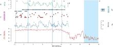
气候变化是影响河流下切和阶地形成的重要驱动因素。Hetzel等(2006)认为全新世的河流下切可能只由气候控制, 而受构造活动影响形成的多级全新世海滨阶地仅在新西兰被发现(Kate et al., 2006; Litchfield et al., 2010)。对于全新世河流阶地, 暖湿条件下河流下切的情况远多于冷干条件下河流下切(Stinchcomb et al., 2012; Sridhar et al., 2013)。下面将童子坝河下切时段与研究区附近东居延泽古湖记录、亚洲地区冰进记录、北大西洋冰筏事件和格陵兰氧同位素曲线进行对比(图 4)。

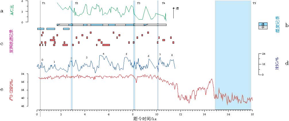
图 4 祁连山东段童子坝河下切时段与其他古气候记录对比
a— 东居延泽古湖孢粉A/C比(Herzschuh et al., 2004); b— 东居延泽古湖湿度重建(Herzschuh et al., 2004); c— 亚洲冰进记录(每行色块出自同一篇文献: Zhou et al., 1991; Lehmkuhl, 1997; Seong et al., 2009; Nazarov et al., 2012; Dortch et al., 2013; Murari et al., 2014); d— 北大西洋冰筏(IRD, ice-rafted debris)记录中的染色赤铁矿在岩屑颗粒中的百分含量(HSG, hematite-stained grains; Bondet al., 2001); e— 格陵兰氧同位素曲线
Fig.4 Comparison of incision period of the Tongziba River, eastern Qilian Mountain with other palaeoclimatic records

T1阶地形成于282.5± 17.5 cal a BP, 气候记录显示气候仍较为湿润; 冰进陆续停止; 北大西洋冰筏事件显示此时期气候在进一步变暖。这一时期的T1阶地的下切可能与小冰期结束或者小冰期内部某一次级的气候由冷转暖事件有关。

T2阶地形成于2900± 60 cal a BP。对应的东居延泽古湖记录显示气候变湿; 冰进记录指示冰川开始消融; 北大西洋冰筏事件显示气候开始由冷转暖, 但格陵兰氧同位素曲线在此时期无明显波动。气候记录总体上显示该时期气候由冷转暖。同时, 这一时期下切的阶地在祁连山北麓的疏勒河、北大河、黑河和石羊河流域(李有利和杨景春, 1997; Pan et al., 2007)、沙沟河(胡春生等, 2006)乃至全球广泛存在(Poisson and Avouac, 2004; Bookhagen et al., 2006; Macklin et al., 2013)。

T3阶地形成于8127.5± 72.5 cal a BP。这一时期东居延泽古湖记录显示气候变湿; 冰进记录指示冰川开始消融; 北大西洋冰筏事件显示气候由冷转暖; 而格陵兰氧同位素曲线在此时期由波谷转向波峰(气温升高)。气候记录显示该时期气候由冷转暖。同时, 这与吴永红等(2006)认为8000— 6200 a BP为明显的温暖期相对应, 此外, 这一时期下切的阶地也存在于黄羊河(胡小飞等, 2013)、疏勒河(胡春生等, 2006)以及北大河、黑河和石羊河流域(李有利和杨景春, 1997)。

T4阶地形成于10 092.5± 27.5 cal a BP或稍早于这一时间, 这级阶地同样被发现于石油河(Hetzel et al., 2006)和疏勒河上游的老虎沟(Hu et al., 2014)。与东居延泽古湖的湿度记录进行对比, 发现气候处于逐渐变湿的过程中; 亚洲冰进记录显示附近的冰进结束, 冰川也开始消融; 北大西洋冰筏事件显示该时期气温由冷转暖; 格陵兰氧同位素曲线也指示了气温处在上升的过程中。同时这时期石羊河流域水量大(王军等, 2010; Li et al., 2011; Long et al., 2012)。因此, T4阶地也形成于气候由冷转暖的时期。

T5阶地年龄位于末次冰期— 全新世的过渡时期, 18 ka BP左右达到末次盛冰期, 之后气候由冷转暖, 且在15— 14 ka BP, 冰川开始迅速消融(李有利和杨景春, 1997), T5阶地正形成于此时期。河西走廊在末次冰期气温比现在低7~9, ℃(Thompson et al., 1989; Wang et al., 2003), 青藏高原东北雪线比现在低1000, m左右。可以设想在末次盛冰期由于寒冷的气候和流量的降低, 研究区河流更长时间是冰冻的, 搬运能力减弱, 大量碎屑无法被搬运和沉积在河西走廊的盆地, 只能加积在狭窄的山谷。从14.8, ka左右开始, 气温上升带来大量冰川和冻土融水, 同时夏季风增强促使降雨增加, 河流搬运能力大于沉积速率, 发生快速下切(Vandenberghe, 2008; Olszak, 2011)。这时期阶地广泛分布于祁连山(胡春生等, 2006; Hetzel et al., 2006; Pan et al., 2007)。

由上所述, T1— T5这5级阶地均是在气候由冷转暖时期下切形成, 往往意味着更多的降水和更大的河流流量, 河流下切能力增强。

5 河流阶地反映的民乐— 大马营断裂垂直错距

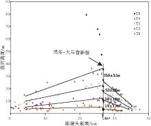
从童子坝河出山口附近阶地高度分布(图5)可以看出, 各级阶地拔河高度在民乐— 大马营断裂附近最大, 而向上、下游河段均逐渐减小, 由于阶地跨过了民乐— 大马营断层, 所以可以根据同一级阶地在民乐— 大马营断层处的位错来分析民乐— 大马营断裂在该处的垂直错距。

图 5 祁连山东段童子坝河出山口附近阶地高度分布Fig.5 Height distribution of terraces near mountain pass of the Tongziba River, eastern Qilian Mountain

由于断裂两侧阶地高度向不同方向减小, 所以对各级阶地断裂两侧的点分别进行一元线性拟合, 得到断裂处95%置信度下各级阶地的累积垂直错距: 从T4阶地形成至今, 民乐— 大马营断裂的累积垂直错距达到10.6± 3.1, m; 从T3阶地形成至今, 民乐— 大马营断裂的累积垂直错距达到5.0± 2.6, m; 从T2阶地形成至今民乐— 大马营断裂的累积垂直错距达到2.0± 1.9, m; 从T1阶地形成至今断裂累积垂直错距均为1.9± 1.3, m。这些数值与分别位于民乐— 大马营断裂的上升盘和下降盘的剖面5和剖面6中同级阶地的高差接近(表 4), 这佐证了使用该方法推断民乐— 大马营断裂在此处的垂直位错是可信的。

表 4 祁连山东段童子坝河各级阶地形成以来民乐— 大马营断裂滑动速率 Table4 Slip rates of the Minle-Damaying fault since the formation time of each terrace of the Tongziba River, eastern Qilian Mountain

童子坝河阶地记录的断层垂直错距说明民乐— 大马营断裂近期的活动历史: 在T4— T3约2000 a之间, 断层活动较为强烈, 垂直活动幅度约5, m; 在T3— T2约5000 a之间, 断层活动有所减弱, 垂直活动幅度约3, m; 而在T2— T1约3000 a之间, 断层活动不明显; 而在T1阶地形成之后, 断层活动有所加强。

根据童子坝河各级断错阶地的形成年代和断裂垂直错距计算得到民乐— 大马营断裂的滑动速率(表4), 速率的不确定度根据年龄的不确定度计算得到。民乐— 大马营断裂滑动速率采用自阶地形成至今的时间段内的平均值来表示。

根据T4阶地自10 092.5± 27.5 cal a BP形成以来累积垂直错距为10.6± 3.1, m, 得到垂直滑动速率为1.05± 0.31, mm/a。前人的研究认为祁连山北缘断裂中部和西部的断层倾角在40° ~60° 之间(Hetzel et al., 2004), 根据这些研究, 假定民乐— 大马营断裂在此处的断层倾角为50° ± 10° , 据此得到民乐— 大马营断裂在此处全新世以来的水平缩短速率为1.02± 0.60, mm/a。

6 结论

通过对祁连山东段童子坝河地貌的分析、阶地年代的测定, 对童子坝河阶地对气候变化与新构造运动的响应进行了研究, 主要得到以下认识:

1)取自阶地砂层样品的年龄为阶地最后堆积的年代, 稍早于阶地下切年代, 大致代表河流下切的下限; 阶地上黄土层底部样品的年龄为阶地下切后阶地面开始沉积黄土的年代, 稍晚于阶地下切年代, 大致代表河流下切的上限。这2类年龄均能代表阶地的下切年代。结合14C和光释光定年, 确定出T5— T1这5级阶地的下切年代分别为16.70± 1.81, ka、 10 092.5± 27.5 cal a BP、8127.5± 72.5 cal a BP、2900± 60 cal a BP、282.5± 17.5 cal a BP; 并与全球气候曲线和区域气候记录进行对比, 结果表明这5级阶地均形成于气候由冷转暖的转型期, 属于气候成因阶地。

2)获得了童子坝河从上游至下游的河床和各级阶地面的高度, 计算了T4— T1阶地在民乐— 大马营断裂处的垂直错距。基于各级阶地的年代和垂直错距, 得到民乐— 大马营断裂全新世以来的垂直滑动速率为1.05± 0.31, mm/a。

The authors have declared that no competing interests exist.

参考文献
[1] 韩金. 2016. 甘肃民乐地区晚更新世以来的气候变迁. 中国地质大学(北京)硕士学位论文.
[Han J. 2016. The Study on Change of Palaeoenvironment in Minle area of Gansu Province since the Late Pleistocene. Master’s Dissertation of China University of Geosciences(Beijing)] [文内引用:1]
[2] 胡春生, 潘保田, 高红山, 徐树建. 2006. 最近150 ka河西地区河流阶地的成因分析. 地理科学, 26(5): 603-608.
[Hu C S, Pan B T, Gao H S, Xu S J. 2006. Analysis of origin river terraces in Hexi area since 150 ka B. P. Scientia Geographica Sinica, 26(5): 603-608] [文内引用:1]
[3] 胡小飞, 潘保田, Kirby E, 李清洋, 耿豪鹏, 陈吉峰. 2010. 河道陡峭指数所反映的祁连山北翼抬升速率的东西差异. 科学通报, 55(23): 2329-2338.
[Hu X F, Pan B T, Kirby E, Li Q Y, Geng H P, Chen J F. 2010. Spatial differences in rock uplift rates inferred from channel steepness indices along the northern flank of the Qilian Mountain, northeast Tibetan Plateau. Chinese Science Bulletin, 55(23): 2329-2338] [文内引用:3]
[4] 胡小飞, 潘保田, 高红山, 胡振波, 曹泊, 李清洋, 耿豪鹏. 2013. 祁连山东段全新世河流阶地发育及其与气候变化的关系研究. 第四纪研究, 33(4): 723-736.
[Hu X F, Pan B T, Gao H S, Hu Z B, Cao B, Li Q Y, Geng H P. 2013. Development of Holocene fluvial terraces in the eastern Qilianshan mountain and its relationship with climate changes. Quaternary Sciences, 33(4): 723-736] [文内引用:1]
[5] 金卿, 何文贵, 史志刚, 袁道阳. 2011. 榆木山北缘断裂古地震特征研究. 地震地质, 33(2): 347-355.
[Jin Q, He W G, Shi Z G, Yuan D Y. 2011. Palaeo-earthquake study on the northern Yumushan active fault. Seismology and Geology, 33(2): 347-355] [文内引用:1]
[6] 李有利, 杨景春. 1997. 河西走廊平原区全新世河流阶地对气候变化的响应. 地理科学, 17(3): 248-252.
[Li Y L, Yang J C. 1997. Response of alluvial terraces to Holocene climatic changes in the Hexi Corridor basins, Gansu, China. Scientia Geographica Sinica, 17(3): 248-252] [文内引用:1]
[7] 李育, 王乃昂, 李卓仑, 周雪花, 张成琦. 2013. 河西走廊盐池晚冰期以来沉积地层变化综合分析: 来自夏季风西北缘一个关键位置的古气候证据. 地理学报, 68(7): 933-944.
[Li Y, Wang N A, Li Z L, Zhou X H, Zhang C Q. 2013. Comprehensive analysis of lake sediments in Yanchi Lake of Hexi Corridor since the late glacial. Acta Geographica Sinica, 68(7): 933-944] [文内引用:1]
[8] 刘兴春. 2000. 民乐山前平原新构造运动及其对地下水埋藏的影响. 甘肃地质, 9(1): 74-79.
[Liu X C. 2000. Neotectonism of Minle Piedmont Plain and its influence on groundwater buried depth. Acta Geologica Gansu, 9(1): 74-79] [文内引用:1]
[9] 闵伟, 张培震, 何文贵, 李传友, 毛凤英, 张淑萍. 2002. 酒西盆地断层活动特征及古地震研究. 地震地质, 24(1): 35-44.
[Min W, Zhang P Z, He W G, Li C Y, Mao F Y, Zhang S P. 2002. Research on the active faults and paleoearthquakes in the Western Jiuquan Basin. Seismology and Geology, 24(1): 35-44] [文内引用:1]
[10] 潘保田, 高红山, 李炳元, 李吉均. 2004. 青藏高原层状地貌与高原隆升. 第四纪研究, 24(1): 50-57.
[Pan B T, Gao H S, Li B Y, Li J J. 2004. Step-Like land forms and uplift of the Qinghai-Xizang Plateau. Quaternary Sciences, 24(1): 50-57] [文内引用:1]
[11] 潘保田, 邬光剑, 王义祥, 刘志刚, 管清玉. 2000. 祁连山东段沙沟河阶地的年代与成因. 科学通报, 45(24): 2669-2675.
[Pan B T, Wu G J, Wang Y X, Liu Z G, Guan Q Y. 2000. Age and genesis of the Shagou River terraces in eastern Qilian Mountains. Chinese Science Bulletin, 45(24): 2669-2675] [文内引用:4]
[12] 王军, 高红山, 潘保田, 杜功元, 李宗盟, 曹泊, 吉亚鹏. 2010. 早全新世沙沟河古洪水沉积及其对气候变化的响应. 地理科学, 17(6): 943-949.
[Wang J, Gao H S, Pan B T. Du G Y, Li Z M, Cao P, Ji Y P. 2010. Pleoflood sediment of Shagou River and its response to the climate change during Early Holocene. Scientia Geographica Sinica, 17(6): 943-949] [文内引用:1]
[13] 王岳. 2016. 河西走廊东西段全新世古湖泊演化对比研究. 兰州大学硕士学位论文, 1-120.
[Wang Y. 2016. The Comparative Study of Paleolakes Evolution between the Eastern and Western Parts of the Hexi Corridor on Holocene. Master’s Dissertation of Lanzhou University, 1-120] [文内引用:1]
[14] 吴永红, 杨太保, 于永涛, 刘晓燕, 安聪荣, 李永飞, 宿星. 2006. 河西走廊全新世气候变迁与古文化响应. 干旱区研究, 23(4): 650-653.
[Wu Y H, Yang T B, Yu Y T, Liu X Y, An C R, Li Y F, Su X. 2006. Holocene climate change and the ancient culture response in central Hexi Corridor. Arid Zone Research, 23(4): 650-653] [文内引用:1]
[15] 杨海波. 2016. 祁连山北缘佛洞庙—红崖子断裂晚第四纪活动速率. 中国地震局地质研究所硕士学位论文, 1-95.
[Yang H B. 2016. Late Quaternary Slip Rates of the Fodongmiao-Hongyazi Fault, Northern Margin of Qilian Shan. Masters Dissertation of Institute of Geology, China Earthquake Administration, 1-95] [文内引用:1]
[16] 郑文俊. 2009. 河西走廊及其邻区活动构造图像及构造变形模式. 中国地震局地质研究所博士学位论文, 1-220.
[Zheng W J. 2009. Geometric Pattern and Active Tectonic of the Hexi Corridor and Its Adjacent Regions. Doctor’s Dissertation of Institute of Geology, China Earthquake Administration, 1-220] [文内引用:1]
[17] An Z S, John E K, Warren L P, Stephen C P. 2001. Evolution of Asian monsoons and phased uplift of the Himalaya-Tibetan plateau since Late Miocene times. Nature, 411(6833): 62-66. [文内引用:1]
[18] Bond G, Kromer B, Beer J, Muscheler R. , Evans M N, Showers W, Hoffmann S, Lotti-Bond R, Hajdas I, Bonani G. 2001. Persistent solar influence on North Atlantic climate during the Holocene. Science, 294(5549): 2130-2136. [文内引用:1]
[19] Bookhagen B, Fleitmann D, Nishiizumi K, Strecker M R, Thiede R C. 2006. Holocene monsoonal dynamics and fluvial terrace formation in the northwest Himalaya, India. Geology, 34(7): 601-604. [文内引用:1]
[20] Chen B, Wang C, Cui L. 2008. Developing model of thrust fault system in western part of northern Qilian Mountains margin-Hexi Corridor basin during late Quaternary. Earth Science Frontiers, 15(6): 260-277. [文内引用:1]
[21] Clark M K, Royden L H. 2000. Topographic ooze: Building the eastern margin of Tibet by lower crustal flow. Geology, 28(8): 703-706. [文内引用:1]
[22] Dortch J M, Owen L A, Caffee M W. 2013. Timing and climatic drivers for glaciation across semi-arid western Himalayan-Tibetan orogen. Quaternary Science Reviews, 78: 188-208. [文内引用:1]
[23] Heermance R V, Chen J, Burbank D W, Wang C S. 2007. Chronology and tectonic controls of Late Tertiary deposition in the southwestern Tian Shan foreland , NW China. Basin Research, 19(4): 599-632. [文内引用:1]
[24] Herzschuh U, Tarasov P, Wünnemann B, Kai H. 2004. Holocene vegetation and climate of the Alashan Plateau, NW China, reconstructed from pollen data. Palaeogeography, Palaeoclimatology, Palaeoecology, 211(1): 1-17. [文内引用:1]
[25] Hetzel R, Niedermann S, Tao M, Kubik P W, Strecker M R. 2006. Climatic versus tectonic control on river incision at the margin of NE Tibet: 10Be exposure dating of river terraces at the mountain front of the Qilian Shan. Journal of Geophysical Research Atmospheres, 111(F3): F03012(1-13). [文内引用:1]
[26] Hetzel R, Tao M X, Stokes S, Niedermann S, Ivy-Ochs S, Gao B, Strecker M R, Kubik P W. 2004. Late Pleistocene/Holocene slip rate of the Zhangye thrust(Qilian Shan, China)and implications for the active growth of the northeastern Tibetan Plateau. Tectonics, 23(6): 159-163. [文内引用:1]
[27] Hu G, Yi C L, Zhang J F, Liu J H, Jiang T, Qin X. 2014. Optically stimulated luminescence dating of a moraine and a terrace in Laohugou valley, western Qilian Shan, northeastern Tibet. Quaternary International, 321(2): 37-49. [文内引用:1]
[28] Kate W, Kelvin B, Nicola L, Tim L. 2006. A revision of mid-late Holocene marine terrace distribution and chronology at the Pakarae River mouth, North Island , New Zealand . New Zealand Journal of Geology and Geophysics, 49(4): 477-489. [文内引用:1]
[29] Kent D V, Muttoni G. 2008. Equatorial convergence of India and early Cenozoic climate trends. Proceedings of the National Academy of Sciences of the United States of America, 105(42): 16065-16070. [文内引用:1]
[30] Lehmkuhl F. 1997. Late Pleistocene, Late-glacial and Holocene glacier advances on the Tibetan Plateau. Quaternary International, 38: 77-83. [文内引用:1]
[31] Li J J, Fang X M, Song C H, Pan B T, Ma Y Z, Yan M D. 2014. Late Miocene-Quaternary rapid stepwise uplift of the NE Tibetan Plateau and its effects on climatic and environmental changes. Quaternary Research, 81(3): 400-423. [文内引用:1]
[32] Li Y, Yang J. 1998. Tectonic geomorphology in the Hexi Corridor, north-west China. Basin Research, 10(3): 345-352. [文内引用:1]
[33] Li Y, Wang N A, Li Z L, Zhang H A. 2011. Holocene palynological records and their responses to the controversies of climate system in the Shiyang River drainage basin. Science Bulletin, 56(6): 535-546. [文内引用:2]
[34] Litchfield N, Wilson K, Berryman K, Wallace L. 2010. Coastal uplift mechanisms at Pakarae River mouth: Constraints from a combined Holocene fluvial and marine terrace dataset. Marine Geology, 270(1): 72-83. [文内引用:1]
[35] Liu X D, Dong B W. 2013. Influence of the Tibetan Plateau uplift on the Asian monsoon-arid environment evolution. Chinese Science Bulletin, 58(34): 4277-4291. [文内引用:1]
[36] Long H, Lai Z P, Fuchs M, Zhang J R, Li Y. 2012. Timing of Late Quaternary palaeolake evolution in Tengger Desert of northern China and its possible forcing mechanisms. Global Planetary Change, 92: 119-129. [文内引用:1]
[37] Lu H H, Zhang T Q, Zhao J X, Si S P, Wang H, Chen S J, Zheng X M, Li Y L. 2014. Late Quaternary alluvial sequence and uplift-driven incision of the Urümqi River in the north front of the Tian Shan, northwestern China. Geomorphology, 219(219): 141-151. [文内引用:1]
[38] Macklin M G, Lewin J, Jones A F. 2013. River entrenchment and terrace formation in the UK Holocene. Quaternary Science Reviews, 76: 194-206. [文内引用:1]
[39] Métivier F, Gaudemer Y, Tapponnier P, Meyer B. 1998. Northeastward growth of the Tibet plateau deduced from balanced reconstruction of two depositional areas: The Qaidam and Hexi Corridor basins, China. Tectonics, 17(6): 823-842. [文内引用:1]
[40] Meyer B, Tapponnier P, Bourjot L, Métivier F, Gaudemer Y, Peltzer G, Guo S M, Chen Z T. 2010. Crustal thickening in Gansu-Qinghai, lithospheric mantle subduction, and oblique, strike-slip controlled growth of the Tibet plateau. Geophysical Journal International, 135(1): 1-47. [文内引用:1]
[41] Molnar P, England P, Martinod J. 1993. Mantle dynamics, uplift of the Tibetan Plateau, and the Indian Monsoon. Reviews of Geophysics, 31(31): 357-396. [文内引用:2]
[42] Murari M K, Owen L A, Dortch J M, Caffee MW, Dietsch C, Fuchs M, Haneberg W C, Sharma M C, Small A T. 2014. Timing and climatic drivers for glaciation across monsoon-influenced regions of the Himalayan-Tibetan orogen. Quaternary Science Reviews, 88: 159-182. [文内引用:3]
[43] Nazarov A N, Solomina O N, Myglan V S. 2012. Variations of the tree line and glaciers in the Central and Eastern Altai regions in the Holocene. Doklady Earth Sciences, 444(2): 787-790. [文内引用:1]
[44] Olszak J. 2011. Evolution of fluvial terraces in response to climate change and tectonic uplift during the Pleistocene: Evidence from Kamienica and Ochotnica River valleys(Polish Outer Carpathians). Geomorphology, 129(1): 71-78. [文内引用:1]
[45] Palumbo L, Hetzel R, Tao M, Li X, Guo J. 2009. Deciphering the rate of mountain growth during topographic presteady state: An example from the NE margin of the Tibetan Plateau. Tectonics, 28(4): 333-345. [文内引用:1]
[46] Palumbo L, Hetzel R, Tao M, Li X. 2011. Catchment-wide denudation rates at the margin of NE Tibet from in situ-produced cosmogenic 10Be. Terra Nova, 23(1): 42-48. [文内引用:1]
[47] Pan B T, Gao H S, Wu G, Li J J, Li B Y, Ye Y G. 2007. Dating of erosion surface and terraces in the eastern Qilian Shan, northwest China. Earth Surface Processes & Land forms, 32(1): 143-154. [文内引用:1]
[48] Pan B T, Hu X F, Gao H S, Hu Z B, Cao B, Ceng H P, Li Q Y. 2013. Late Quaternary river incision rates and rock uplift pattern of the eastern Qilian Shan Mountain, China. Geomorphology, 184(430): 84-97. [文内引用:1]
[49] Patriat P, Achache J. 1984. India-Eurasia collision chronology has implications for crustal shortening and driving mechanism of plates. Nature, 48(2): 183-183. [文内引用:3]
[50] Poisson B, Avouac J. 2004. Holocene hydrological changes inferred from alluvial stream entrenchment in North Tian Shan(Northwestern China). The Journal of Geology, 112(2): 231-249. [文内引用:1]
[51] Reimer P J, Bard E, Bayliss A, Beck J W, Blackwell P G, Ramsey C B, Buck C, Cheng H, Edwards R L, Friedrich M, Grootes P M, Guilderson T P, Haflidason H, Hajdas , Hatte C, Heaton T J, Hoffmann D L, Hogg A G, Hughen K A, Kaiser K F, Kromer B, Manning S W, Niu M, Reimer R W, Richards D A, Scott E M, Southon J R, Staff R A, Turney C, Plicht J. 2013. IntCal13 and Marine13 radiocarbon age calibration curves 0-5000 years cal BP. Radiocarbon, 55(4): 1869-1887. [文内引用:1]
[52] Seong Y B, Kang H C, Ree J H, Choi J H, Lai Z P, Long H, Yoon H O. 2011. Geomorphic constraints on active mountain growth by the lateral propagation of fault-related folding: A case study on Yumu Shan, NE Tibet. Journal of Asian Earth Sciences, 41(2): 184-194. [文内引用:2]
[53] Seong Y B, Owen L A, Yi C L, Finkel R C. 2009. Quaternary glaciation of Muztag Ata and Kongur Shan: Evidence for glacier response to rapid climate changes throughout the Late Glacial and Holocene in westernmost Tibet. Geological Society of America Bulletin, 121(3-4): 348-365. [文内引用:1]
[54] Sridhar A, Chamyal L S, Bhattacharjee F, Singhvi A K. 2013. Early Holocene fluvial activity from the sedimentology and palaeohydrology of gravel terrace in the semi arid Mahi River Basin, India. Journal of Asian Earth Sciences, 66: 240-248. [文内引用:1]
[55] Starkel L. 2003. Climatically controlled terraces in uplifting mountain areas. Quaternary Science Reviews, 22(20): 2189-2198. [文内引用:1]
[56] Stinchcomba G E, Nordt L C, Allen P M. 2012. A mid to late Holocene history of floodplain and terrace reworking along the middle Delaware River valley, USA. Geomorphology, 169: 123-141. [文内引用:1]
[57] Stuiver M, Grootes P M, Braziunas T F. 1995. The GISP2 δ18O climate record of the past 16 500 years and the role of the Sun, ocean, and volcanoes. Quaternary Research, 44(3): 341-354. [文内引用:3]
[58] Tapponnier P, Meyer B, Avouac J P, Peltzer G, Gaudemer Y, Guo S M, Xiang H F, Yin K L, Chen Z T, Cai S H, Dai H G. 1990. Active thrusting and folding in the Qilian Shan, and decoupling between upper crust and mantle in northeastern Tibet. Earth & Planetary Science Letters, 97(3-4): 382-383. [文内引用:1]
[59] Thompson L G, Mosleythompson E, Davis M E, Bolzan J F, Dai J, Yao T, Gundestrup N, Wu X, Klein L, Xie Z. 1989. Holocene-Late Pleistocene climatic ice core records from Qinghai-Tibetan Plateau. Science, 246(4929): 474-477. [文内引用:1]
[60] Vand enberghe J. 2008. The fluvial cycle at cold-warm-cold transitions in lowland regions: A refinement of theory. Geomorphology, 98(3): 275-284. [文内引用:1]
[61] Wang N, Zhao Q, Li J, Hu G, Cheng H. 2003. The sand wedges of the last ice age in the Hexi Corridor, China: Paleoclimatic interpretation. Geomorphology, 51(4): 313-320. [文内引用:1]
[62] Xiao G Q, Guo Z T, Dupont-Nivet G, Lü H Y, Wu N Q, Ge J Y, Hao Q Z, Peng S Z, Li F J, Abels H A, Zhang K X. 2012. Evidence for northeastern Tibetan Plateau uplift between 25 and 20 Ma in the sedimentary archive of the Xining Basin, Northwestern China. Earth & Planetary Science Letters, 317: 185-195. [文内引用:1]
[63] Yin A, Harrison T M. 2000. Geologic evolution of the Himalayan-Tibetan Orogen. Annual Review of Earth & Planetary Sciences, 28(28): 211-280. [文内引用:2]
[64] Zhang H C, Ma Y Z, Wunnemann B, Pachur H J. 2000. A Holocene climatic record from arid northwestern China. Palaeogeography, Palaeoclimatology, Palaeoecology, 162(3): 389-401. [文内引用:1]
[65] Zheng D W, Clark M K, Zhang P Z, Zheng W J, Farley K A. 2010. Erosion, fault initiation and topographic growth of the North Qilian Shan(northern Tibetan Plateau). Geosphere, 6(6): 937-941. [文内引用:1]
[66] Zheng W J, Zhang P Z, Ge W P, Molnar P, Zhang H P, Yuan D Y, Liu J H. 2013. Late Quaternary slip rate of the South Heli Shan Fault(northern Hexi Corridor, NW China)and its implications for northeastward growth of the Tibetan Plateau. Tectonics, 32(2): 271-293. [文内引用:1]
[67] Zhou S Z, Chen F H, Pan B T, Cao J X, Li J J. 1991. Environmental change during the Holocene in western China on a millennial timescale. Holocene, 1(2): 151-156. [文内引用:1]
[68] Zuza A V, Cheng X, Yin A. 2016. Testing models of Tibetan Plateau formation with Cenozoic shortening estimates across the Qilian Shan-Nan Shan thrust belt. Geosphere, 12(2): 501-532. [文内引用:1]