京津冀地区历史地震事件时空特征研究*
胡慧文1, 王永波1, 蒋汉朝2, 李珍1, 胡雪婧1, 韩羽佳1
1首都师范大学资源环境与旅游学院,北京 100048
2中国地震局地质研究所,北京 100029

通讯作者简介 王永波,男,1983年生,毕业于南京大学,在德国波茨坦大学获博士学位。现为首都师范大学资源环境与旅游学院副教授,硕士生导师,主要从事自然地理学全球气候环境演化等研究。E-mail: yongbowang@cnu.edu.cn

第一作者简介 胡慧文,女,1998年生,首都师范大学资源环境与旅游学院本科毕业,现为北京师范大学硕士研究生,主要从事自然地理学研究。E-mail: 1075587169@qq.com

摘要

受环太平洋地震带影响,华北平原地区地震频发,尤其是处于中国首都经济圈的京津冀地区的地震事件备受关注。通过对历史文献资料及地震台网记录中的地震事件统计、分析,重建该地区地震事件历史并获取其潜在的空间分布特征及时间规律,对未来地震事件的早期预警具有重要参考意义。分析结果表明,公元前231年至公元2018年期间京津冀地区发生的1044起地震事件中,以有感地震和中强地震为主,小地震、强烈地震以及大地震发生频次较低。地震记录完整性分析结果表明,除小地震外,其他等级地震记录自公元1400年以来基本完整。在空间分布上,京津冀地区历史地震呈“T”字形分布,沿1条北西—南东走向地震带和1条北东—南西走向地震带分布。在时间上,京津冀地区地震事件呈现出阶段性的变化,在公元1480—1680年间以及1950年以来2个时间段内较为活跃,发生频率较高,频谱分析结果进一步表明地震记录存在45年的复发周期。在月际尺度上,地震事件同样存在季节性差异且多发于夏秋季节,同时地震密集区域在年内呈现出自西向东迁移的现象。最后,根据历史地震事件发生的时间规律,在未来一段时间内京津冀地区仍将处于地震活跃期,存在发生强震的风险。

关键词: 京津冀; 历史地震; 时空特征; 地震周期
中图分类号:P954 文献标志码:A 文章编号:1671-1505(2021)02-0435-14
Spatial-temporal distribution of historical earthquake events in Beijing-Tianjin-Hebei area
Hu Hui-Wen1, Wang Yong-Bo1, Jiang Han-Chao2, Li Zhen1, Hu Xue-Jing1, Han Yu-Jia1
1 College of Resource Environment and Tourism,Capital Normal University,Beijing 100048,China
2 Institute of Geology,China Earthquake Administration,Beijing 100029,China

About the corresponding author Wang Yong-Bo,born in 1983,is an associated professor with a Ph.D. degree obtained from University Potsdam,Germany. He is a supervisor of master’s degree candidate,and is mainly engaged in researches on physical geography focusing on past global climate and environmental changes. E-mail: yongbowang@cnu.edu.cn.

About the first author Hu Hui-Wen,born in 1998,undergraduate student in Capital Normal University,is a master degree candidate at Beijing Normal University. She is mainly engaged in researches on physical geography. E-mail: 1075587169@qq.com.

Abstract

The North China Plain is located in the Circum-Pacific Seismic Belt where earthquakes occur frequently. The Beijing-Tianjin-Hebei area,which is the capital economic circle,has attracted much attentions. It is of great significance for the reconstruction of earthquake history to obtain the spatial and temporal distribution characteristics in this region,which may provide important reference for the early warning of earthquake events in the future. Therefore,earthquake events recorded in historical documents and seismic stations were collected and analyzed in this study. The results show that 1044 earthquake events were recorded in Beijing-Tianjin-Hebei area between 231 BC and 2018 AD. The felt earthquakes and moderate earthquakes were the main types,while small earthquakes,strong earthquakes and major earthquakes showed rather low frequencies. The seismic record integrity analysis confirms that the earthquake( M>3)records were basically complete since 1400 AD,which could be used for statistical analyses. The historical earthquakes in Beijing-Tianjin-Hebei area represent a T-shape spatial distribution,consisting of a northwest to southeast seismic zone and a northeast to southwest seismic zone. The historical earthquake records presented periodic variations,showing much higher frequencies during the periods of ca. 1480-1680 AD and after 1950 AD. The spectral analysis on the earthquake frequency sequence yields a recurrence period of 45 years,which represents a kind of recurrence time for the high frequent earthquake years. In addition,the earthquake events expressed monthly variations as well,revealing higher frequencies during summer and autumn months,along with a seasonal migration of high frequency region from west to east in the study area. Finally,according to the temporal distribution of the earthquake events,the Beijing-Tianjin-Hebei area will possibly experience a period of high potential of destructive earthquakes in the near future.

Key words: Beijing-Tianjin-Hebei area; historical earthquake; temporal and spatial pattern; earthquake period
1 概述

地震作为一种破坏力极强的自然灾害, 具有突发性和难预测性的特点, 能够在极短时间内造成严重人员伤亡及财产损失, 如近年来发生的汶川地震(2008年; Cui et al., 2011)、玉树地震(2011年; Xu et al., 2012)等。同时, 地震所诱发的海啸、滑坡等次生地质灾害(Cui et al., 2009; Fan et al., 2012; Xu et al., 2014), 同样对社会经济发展构成重要威胁, 如2011年日本发生里氏9.0级地震并诱发海啸造成巨大灾难(Mori et al., 2011; Gusman et al., 2012), 备受大众及研究学者关注。

已有研究表明, 地震的发生具有一定规律性, 在一定时间尺度上可重复发生(Kanamori, 1977; Xu and Deng, 1996), 因而探讨历史时期内发生的地震事件时空规律对于地震的早期预警具有重要意义。利用公元2至1995年间的历史地震资料对朝鲜半岛地震灾害进行评估, 发现该地区存在4个突出的地震带(Chiu and Kim, 2004)。研究学者通过编制地震震级目录等方法对印度半岛地震灾害的时空变异性进行研究, 为印度半岛地震危险性评估和微观区划研究提供了有力依据(Jaiswal and Sinha, 2008)。利用地震历史资料, 孙文斌(1994)对日本海地区强震活动时空变化特征进行了探讨。杨格格等(2011)在编制地震灾害图谱的基础上, 从不同时空尺度定量分析了近60年来中国地震灾害的时空分布格局。任慧子和曹小曙(2011)通过整理公元前1831年至公元1980年间地震灾害资料, 探讨了中国地震灾害的时空特征尤其是地震灾害对交通空间分布的影响。此外, 众多学者利用区域性的历史地震资料, 如中国东南沿海地区(顾方琦, 1989)、甘肃省(裴惠娟等, 2015)和云南地区等(张彬等, 2006), 对区域性的地震活动时空演化特征进行了梳理分析, 为理解不同区域地震事件发生规律提供了重要参考依据。由此可见, 历史资料中保存的地震记录在探讨地震事件发生规律上具有重要作用。

京津冀地区作为中国的首都经济圈, 是中国北方地区经济规模最大、最具活力的地区, 在中国区域经济格局中占据无法替代的战略地位(陆大道, 2015)。同时, 京津冀地区地处环太平洋地震带, 地震活动频发。历史上, 该地区发生了多次7级以上强震事件(图 1; 表 1), 如1679年三河— 平谷8.0级地震、1830年磁县7.5级地震; 近代以来同样记录多次强震, 如1966年3月邢台地区6.8级和7.2级地震, 以及1976年7月河北省唐山丰南一带里氏7.8级地震(刘恢先, 1985; 徐杰等, 1996)。通过分析华北平原历史上6.0级以上地震记录并结合主要构造断裂带运动速度资料, Yin等(2014)提出该地区存在潜在地震空白期, 在未来存在发生强震的潜势。

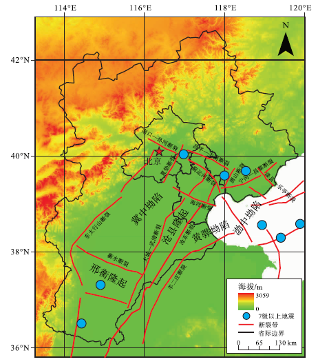
图 1 京津冀地区地形图及历史记录7级以上强震位置(断裂带根据段永红等, 2015; 范友良等, 2017)Fig.1 Topography of Beijing-Tianjin-Hebei area and locations of historical strong earthquakes(M> 7)(distribution of structural ruptures after Duan et al., 2015; Fan et al., 2017)

表 1 京津冀地区历史强震(大于7.0级)事件记录 Table1 Historical strong earthquakes(M> 7.0)in Beijing-Tianjin-Hebei area

自2019年以来, 京津冀地区同样发生了多次地震事件(表 2), 备受研究学者关注。通过对京津冀及周边地区2007— 2016年间地震事件利用双差地震定位法进行分析, 谢卓娟等(2017)发现该地区地震主要集中在唐山、邢台、张渤带西段和文安地区。刘亢等(2015)以地震学与构造地质学为理论基础, 对唐山、滦县地区地震数据进行时间、空间综合分析, 发现古冶东侧存在1条新生地震带。此外, 研究还发现地壳垂直运动信息对地震危险区的判定具有很好的指示意义, 根据地震活动统计发现地震活动分布具有明显的分区规律和迁移现象(孟宪纲等, 2017)。近期研究还表明, 华北地区主要断裂带上库仑应力的增加意味着断层更趋于破裂, 进而触发地震, 而库仑应力降低则表明断层发震时间被推迟(张群伟和朱守彪, 2019)。

表 2 京津冀地区2019年4月至2020年5月地震事件记录 Table2 Recent earthquake events in Beijing-Tianjin-Hebei area between April 2019 and May 2020

由上可见, 众多学者对京津冀乃至华北地区地震活动开展了大量研究工作, 从不同的角度对区域地震事件发生的规律以及机制进行了探讨, 取得了显著的成果。然而, 目前尚缺乏对该地区历史地震事件时空特征的系统研究。通过收集和整理地震台网以及历史文献资料中保存的京津冀地区地震事件, 利用地学统计分析方法获取地震事件发生的时空分布特征, 以期为京津冀地区的地震危险性趋势评价提供参考。

2 区域构造背景

京津冀地区(约113° 04'~119° 53'E, 36° 01'~42° 37'N)地处华北地堑的北缘, 位于燕山以南, 太行山东侧, 为燕山构造带与太行山山前断裂带的交汇带(杨国华等, 2002)。从地质构造上, 华北平原在经历了古近纪差异性裂陷和新近纪以来的整体沉陷之后(张世民等, 2006), 该地区的活动断裂多为晚更新世或全新世断裂且走向大致分为2组, 即北东或北东东向和北西西或北西向(徐锡伟等, 2002)(图 1)。其中, 前者的活动断裂主要分布于太行山隆起带及华北平原区, 而后者的活动断裂主要分布于张家口— 蓬莱构造带, 活动断裂的组合形式作为燕山隆起带、华北平原区、张家口— 蓬莱构造带的分界线, 构成了该区地表地质构造的基本格局(牛琳琳, 2018)。研究发现, 京津冀地区地震的发生与构造活动的迁移趋势也是一致的(许桂林和范国胜, 1986)。冀中、黄骅地区的构造活动由南而北发展, 上新世以来向北已穿过华北盆地到了燕山隆起边缘, 这一地区新近纪至第四纪的活动断裂较为发育, 且活动较强烈, 强震频繁发生。渤中坳陷是华北盆地主体部位的沉降中心, 自公元1500年以来已发生3次7级及以上的地震(环文林等, 1989)。

3 数据来源与分析方法
3.1 地震事件来源及数据统计

本研究所收集到的历史地震事件数据来源于《中国近代地震目录》(中国地震局震害防御司, 1999)、《中国历史有感地震目录》(刁守中和晁洪太, 2008)、《中国历史强震目录》(国家地震局震害防御司, 1995), 以及中国地震台网(http://www.csi.ac.cn, http://www.ceic.ac.cn)和美国地质勘探局网站(https://www.usgs.gov)公布的地震事件资料。筛除不同资料中的重复记录后, 共得到具备地震时间、震中位置、震级大小等要素信息的地震记录1044条。通过对所有历史地震数据进行整合, 按震感分为小地震(M≤ 3)、有感地震(3< M≤ 4.5)、中强地震(4.5< M≤ 6)、强烈地震(6< M≤ 7)、大地震(7< M≤ 8)和巨大地震(M> 8)。

通过整理发现, 公元前231年至公元2018年京津冀地区共保存1044次地震记录, 主要以有感地震和中强地震为主, 其中有感地震发生773次, 中强地震发生205次, 分别占地震总次数的74%和19%, 其他级别地震发生频次较低, 小地震41次、强烈地震20次、大地震5次(表 3), 分别占总地震次数的4%、2%、1%。从整体上看, 京津冀地区地震次数以河北省为最多, 各省市以有感地震占比最大。根据地震震中位置进行划分后发现, 京津冀地区的地震主要分布在河北省, 北京市和天津市的地震发生次数较低。河北省作为京津冀地区地震的高发区, 共发生地震798次, 占地震发生总次数的76%, 以有感地震和中强地震为主。另外, 强烈地震和大地震的发生次数也高于北京市与天津市。其次为北京市, 共发生地震208次, 占地震总次数的20%, 以有感地震为主。天津市发生地震次数最低、强度最弱, 为38次, 占地震总数的4%, 以有感地震和小地震为主(表 3)。

表 3 京津冀地区公元前231年至公元2018年地震记录汇总统计 Table3 Summary of historical earthquake records in Beijing-Tianjin-Hebei area between 231 BC and 2018 AD
3.2 地震记录完整性及数据分析方法

在数据搜集整理过程中发现, 尽管京津冀地区地震记录最早可以追溯至公元前231年, 但记录主要集中在公元1400年以后的时段, 并且以有感地震及以上强度记录为主, 小于3级的小地震记录明显偏少(表 3), 表明地震记录存在一定的缺失(不完整)现象。已有研究表明, 由于编制统计方法不同、记录文献丢失等多种原因, 历史地震目录可能存在缺失, 尤其是年代久远的地震记录(黄玮琼等, 1994a; 徐伟进和高孟潭, 2014), 因而在利用历史地震目录中记录资料时应对地震记录的完整性进行检验。

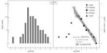
对于同一地震区完整的地震记录而言, 地震记录频次的对数与地震等级呈线性相关(Rydelek and Sacks, 1989), 进而可以利用该方法检验地震记录的完整性(黄玮琼等, 1994a, 1994b)。从图 2-A中发现, 京津冀地区公元1400年以来小地震(M≤ 3)记录明显偏少, 而强度在有感地震及以上(M> 3)记录频次对数与震级间存在显著的线性相关关系(R2=0.97)且均分布于95%置信区间内(图 2-B), 表明除小地震外, 京津冀地区公元1400年以来地震记录基本完整。此外, 关于华北地区历史地震记录完整性研究也发现公元1484年(黄玮琼等, 1994a, 1994b)或公元1500年(徐伟进和高孟潭, 2014)以来地震记录较为完整, 与本研究的结果基本一致。

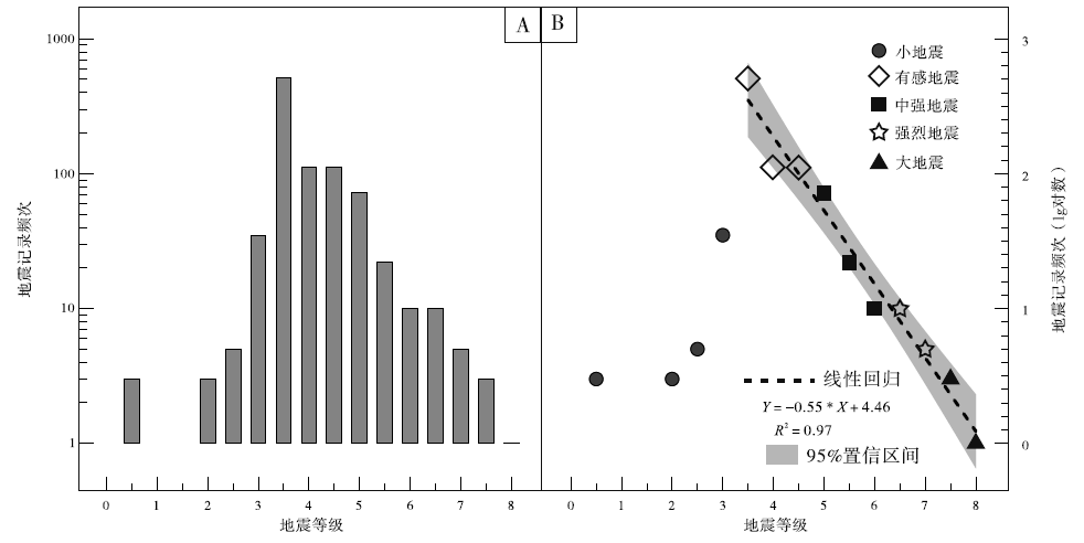
图 2 京津冀地区公元1400年以来地震等级与地震记录频次(A)、地震频次对数(B)的关系Fig.2 Correlation of earthquake magnitude with event frequencies(A)and logarithm of event frequencies(B) since 1400 AD in Beijing-Tianjin-Hebei area

因而, 本研究对1400年以来大于3级的地震事件进行统计分析, 为获取历史地震事件的时间演化规律, 以5年为时间窗口统计地震记录频次, 利用Redfit软件进行频谱分析以获得地震事件的潜在周期(Schulz and Mudelsee, 2002)。在空间上, 运用ArcGIS软件对京津冀地区历史地震的空间分布进行展示; 同时, 为了更清晰地获取地震分布特征, 对研究区域按0.5° × 0.5° 的网格创建渔网并与地震事件数据进行空间连接, 计算各网格内地震事件的空间密度。

4 京津冀地区历史地震空间分布特征

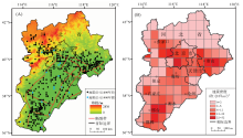
从京津冀地区历史地震记录分布图(图 3)中可以看出, 该地区地震主要呈“ T” 字形分布, 由北西— 南东走向、北东— 南西走向2条地震带组成。

图 3 京津冀地区历史地震事件分布(A)及1400年以来3级以上地震空间密度(B)Fig.3 Distribution of historical earthquake events(A) and spatial density of earthquake events(M> 3)since 1400 AD (B) in Beijing-Tianjin-Hebei area

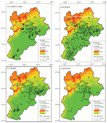
第1条地震带自北西向南东贯穿京津冀地区, 经过河北省张家口市、北京市、天津市以及河北省唐山市; 第2条地震带自北东向南西依次贯穿北京市主城区、河北省保定市、廊坊市、沧州市、衡水市、邢台市至邯郸市并向南部延伸(图 3)。同时, 受到地质构造环境影响, 京津冀地区不同震级的地震在空间分布上同样存在一定差异(图 4)。京津冀地区的小地震事件数量较少, 存在一定的缺失(图 2), 主要分布在北京、天津两地以及河北省的南部(图 4-A)。有感地震作为统计资料中发生频次最多的事件, 呈现出明显的“ T” 字形分布特征, 主要在张家口— 唐山、北京— 邯郸地区密集分布(图 4-B)。与有感地震相比, 京津冀地区发生中强地震的次数明显减少, 统计资料中共记录205次, 主要集中分布在北西— 南东向地震带以及河北省南部(图 4-C)。京津冀地区发生强烈地震20次, 除部分发生在北京、天津外, 主要分布在河北省南部的邢台地区、西部的张家口和东部的唐山地区, 尤其是在其南部的邢衡隆起处分布最为集中(图 4-D)。据资料统计, 京津冀地区发生的大地震共5次, 主要分布在河北省邢台市和唐山市附近(图 4-A), 且在统计年限内发生的大地震以1976年的唐山地震影响最大。

图 4 京津冀地区不同震级历史地震记录空间分布Fig.4 Distribution of historical earthquake records with different magnitude in Beijing-Tianjin-Hebei area

其中, 沿北西— 南东走向的地震带, 地震多发区主要集中在张家口地区、北京市中部及唐山地区(图 3-B)。张家口地区位于张家口— 蓬莱断裂和山西断陷盆地北端的晋冀北张性构造区, 尤其是张家口— 蓬莱断裂带由近20条断裂组成(徐杰等, 1998), 控制着该地区新生代构造活动, 此外该区域还受到山西断裂带的影响, 沿断裂带曾发生一系列地震事件(祝治平等, 1999; Xu et al., 2001)。北京中部的地震多发区主要位于南口— 孙河断裂及周围地区(江娃利等, 2001), 以及北京与天津市交界处的夏垫断裂及周围地区(黄礼良, 1997), 地震分布沿断裂呈北东— 南西走向。此外, 沿昌平— 丰南断裂、蓟运河断裂、唐山断裂、宁河— 昌黎断裂及滦县— 乐亭断裂等, 在天津北部及河北唐山地区同样多发地震。

另外, 沿北东— 南西走向的地震带, 地震多发地区主要集中于河北省南部的邢台地区和邯郸地区(图 3-B)。地震主要沿着东太行山断裂、大城— 武清断裂呈条带状分布, 冀中坳陷在东太行山断裂与大城— 武清断裂之间, 地震较为分散(图 3-A)。沧县隆起位于大城— 武清断裂东侧, 该地区地震沿断裂呈北东— 南西条带状分布, 并向东部的羊二庄断裂处延伸。石家庄南部、邢台地区、邯郸地区地震发生频次高、分布密集。石家庄南部地区的地震分布沿东太行山断裂呈北西— 南东走向, 衡水断裂位于邢衡隆起的北部, 地震多沿衡水断裂带呈北西— 南东分布(刘博研等, 2015)。在邢衡隆起地区及邯郸地区, 地震分布较为集中, 邢衡隆起处的中强地震和强烈地震偏多, 邯郸地区以有感地震为主, 分布密集(国家地震局地震测量队, 1975)。

综上所述, 河北省西部、东部、南部地震发生频次高、分布较为集中, 密度大, 各级地震均有分布; 北京市中部地震较为集中, 密度大, 以有感地震与强烈地震为主; 天津市地震发生频次较低, 分布较为稀疏, 以小地震和有感地震为主, 该分布特征与谢卓娟等(2017)开展地震重新定位研究的结果一致。河北省在活动断层交汇区及活动断层两端、拐点、分支、分叉部位和断陷盆地边界地区地震多发, 一定程度上是因为这些部位处于应力集中地区(刘燕翔等, 2017)。

5 京津冀地区历史地震时间分布特征
5.1 京津冀地区不同历史时期地震事件

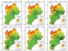
为了更清晰地展示京津冀地区不同历史时期地震记录分布情况, 根据历史朝代划分为6个时段(图 5)。从中可以看出, 在明朝之前只在京津冀地区中南部有零星记录, 自明朝起迅速扩展到整个地区, 呈“ T” 字形分布, 在河北省张家口市、邢台市、唐山市和北京中部呈现4个密集分布区, 这种格局一直延续到新中国成立后。由此可见, 在1966年邢台地震和1976年唐山地震发生之前, 该地区就是地震活动的密集区(图 5)。在时间分布上, 由于地震记录的不完整性, 京津冀地区在明朝以前的时段整体上地震记录较为有限, 自明朝起地震事件频次明显增加, 尤其是在新中国成立后, 地震事件记录进一步增加。在划分的历史时期中, 明朝发生地震的地震次数是整个历史时期最多的, 其次是清朝, 该研究结果与已有明清时代地震事件的研究结果一致(童鹏飞, 2010; 朱凤祥, 2011)。

图 5 京津冀地区历史朝代地震记录空间分布Fig.5 Distribution of earthquake records for certain historical periods in Beijing-Tianjin-Hebei area

5.2 京津冀地区历史地震事件周期规律

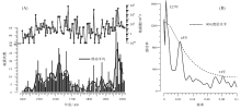
根据地震记录完整性分析结果(图 2), 选取公元1400年以来的3级以上地震记录数据进行分析, 探讨地震事件发生的时间规律(图 6)(Shelly, 2010)。从图 6-A中可以看出京津冀地区历史地震活动在时间上呈现出一定的阶段性和周期性的变化。地震事件在1480— 1680年间以及1950年以来2个时间段内较为活跃, 发生频率较高; 相应的, 在1680— 1950年间地震发生频次相对较低(图 6-A)。地震的发生伴随着大量的能量释放, 并且所释放的能量随震级呈指数增加(Gutenberg and Richter, 1956), 公元1400年以来3级以上地震事件释放能量与地震频次呈现较为一致的变化趋势(图 6-A), 进一步验证了地震事件的阶段性规律。另一方面, 自1400年以来该地区经历了数个地震活跃期和平静期, 呈现出间隔40~50年左右的周期性规律(图 6-A)。频谱分析结果也表明京津冀地区历史地震事件存在327年、45年和12年3个显著周期(超过了90%置信水平; 图 6-B), 其中327年周期反映了地震事件的长期阶段性, 而45年周期则与地震事件的周期性复发有关, 该发现与中国强震存在50年周期的研究结论(黄圣睦和董瑞英, 1997)一致。此外, 现代构造应力场与孕震环境的分析也表明京津冀地区强震的平静期和活跃期存在50~100年的周期(牛琳琳, 2018)。

图 6 京津冀地区1400年以来3级以上历史地震事件频次和地震能分布(A)以及地震频次频谱分析结果(B)Fig.6 Temporal pattern of historical earthquake records(M> 3)and earthquake energy since 1400 AD(A)and results of spectral analysis based on earthquake frequency in Beijing-Tian-Hebei area

5.3 京津冀地区历史地震事件月际变化

除了前文所描述的长时间尺度周期性和阶段性, 京津冀地区地震事件在月际尺度上同样存在规律性变化(图 7)。通过分析公元1400年以来不同月份3级以上地震次数可以发现, 京津冀地区历史地震月变化较为明显, 除3月份地震频次较高外, 1月份至7月份地震发生频次呈现递增趋势, 随后有所降低, 尤其是10至12月地震频次明显偏低, 表明夏秋季节是京津冀地区地震的高发期, 而冬春季节地震活动相对较少(Oldham, 1918; Matsumura and Oike, 1985)。在上个世纪初期对印度地震记录的分析也发现夏季地震发生频次高于冬季(Oldham, 1918), 美国旧金山地区1906年以前地震事件存在清晰季节性变化且集中在春季(McClellan, 1984), 日本历史地震记录研究发现小地震不具有明显的季节性规律, 而7.5级以上大地震呈现出季节性变化(Mogi, 1969)。对朝鲜半岛及中国陆地地震事件进行统计之后同样发现7.5级以上地震在5— 7月份多发(Matsumura and Oike, 1985), 与分析结果一致。有研究认为, 地震的发生与地球自转速率变化有关(陈学忠等, 2010), 地球自转速率变化会引起地表块体运动差异进而诱发地震; 同时研究资料表明, 夏季和秋季地球自转速度比全年平均速度大(虞志英等, 1974), 而京津冀地区存在多条断裂, 为地震的发生提供了条件。

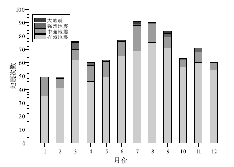
图 7 京津冀1400年以来3级以上历史地震事件月际分布Fig.7 Monthly variation in frequency of earthquake records (M> 3)since 1400 AD in Beijing-Tianjin-Hebei area

另一方面, 京津冀地区地震事件在月际间除了频次变化之外, 地震活动在空间分布上也呈现出一定的演变规律(图 8)。从图 8-A中可以发现, 1— 2月份地震记录集中分布在张家口市、唐山市和邢台市附近, 周边有零散的地震活动记录。自3月起, 地震发生次数明显增多, 呈现出与总体格局类似的“ T” 字形(图 8-B)。随后在5— 6月份, 地震活动格局变化不大, 河北省南部的地震活动密度最大, 并逐渐由西部向东部蔓延(图 8-C)。之后, 在7— 8月份, 地震活动密度最大的地区转移到河北省东部(图 8-D)。进入10月份起, 地震活动密度最大的地区再次转移到河北省西部和南部, 北京中部、河北省东部各月均有地震分布, 但密度变化不大(图 8-E, 8-F)。从地震记录在月际尺度上的空间分布可以看出, 地震活动存在一定的空间迁移现象。这一结果与燕山地震带地震活动自西向东迁移的现象基本一致, 即地震活动迁移到首都圈东区后会跳回首都圈西区开始新的轮回, 并且这一定向路径是可重复的(马宗晋和李献智, 1992)。研究发现, 地震的这种表现特征与其地质构造环境是有一定关系的, 位于华北平原的京津冀地区, 受西太平洋板块和印度板块的作用, 二者控制着华北的新构造运动, 导致地震出现成片迁移的现象(王亚茹和王想, 2018)。根据大陆岩石圈网络状塑性流动与多层构造变形的观点, 有研究认为在印度板块的推挤作用下, 亚洲中东部大陆存在着不同准周期的塑性流动波, 造成地震活动沿塑性流动网带的迁移(王绳祖, 1993; 王绳祖和张宗淳, 1994)。

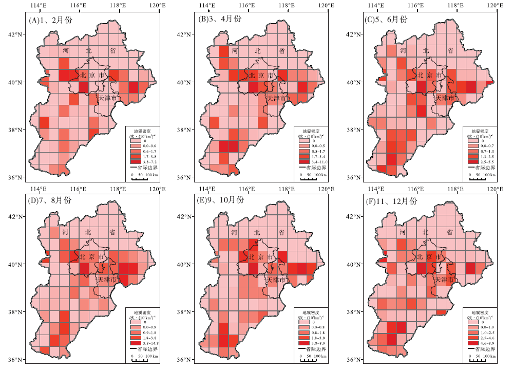
图 8 京津冀地区1400年以来3级以上历史地震事件空间密度月际分布变化Fig.8 Monthly variation in spatial density of historical earthquakes(M> 3)since 1400 AD in Beijing-Tianjin-Hebei area

6 结论

通过对历史资料及地震台网中记录的公元前231年至公元2018年间京津冀地区1044起地震事件记录进行统计分析, 发现该地区历史地震记录以有感地震和中强地震为主, 强烈地震以及大地震的发生频率较低。地震记录完整性分析表明公元1400年以来3级以上地震记录基本完整, 并且在空间分布及发生时间上具有一定的规律性。空间分布上, 京津冀地区历史地震主要呈“ T” 字形分布, 由北西— 南东走向和北东— 南西走向2条地震带组成, 前者自北西向南东贯穿京津冀地区, 后者自北东向南西贯穿北京市中部、河北省中部与南部。地震记录的空间分布与区域构造断裂带分布一致, 主要集中在张家口— 渤海地震构造带、邢衡隆起以及大城— 武清断裂带。在时间尺度上, 公元1400年以来3级以上地震事件的发生呈现一定的阶段性和周期性, 频谱分析结果揭示了327年和45年2个主要周期。此外, 地震记录在月际尺度上同样变化明显, 地震事件在夏秋季节多发, 并且地震密集发生位置随季节呈现出自西向东的迁移过程。

致谢 两位匿名审稿专家对论文的修改提出宝贵建议, 在此深表感谢!

(责任编辑 李新坡; 英文审校 刘贺娟)

参考文献
[1] 陈学忠, 李艳娥, 赵晓燕. 2010. 地球自转、地震成因与地震预报. 国际地震动态, 30(1): 18-24.
[Chen X Z, Li Y E, Zhao X Y. 2010. The earth rotation, the cause of earthquakes and earthquake prediction. Recent Developments in World Seismology, 30(1): 18-24] [文内引用:1]
[2] 刁守中, 晁洪太. 2008. 中国历史有感地震目录. 北京: 地震出版社, 1-538.
[Diao S Z, Chao H T. 2008. Catalog of Historical Felt Earthquakes in China. Beijing: Seismological Press, 1-538] [文内引用:1]
[3] 段永红, 刘保金, 赵金仁, 刘保峰, 张成科, 潘素珍, 林吉炎, 郭文斌. 2015. 华北构造区岩石圈二维P 波速度结构特征: 来自盐城—包头深地震测深剖面的约束. 中国科学: 地球科学, 45(8): 1183-1197.
[Duan Y H, Liu B J, Zhao J R, Liu B F, Zhang C K, Pan S Z, Lin J Y, Guo W B. 2015. 2-D P-Wave velocity structure of lithosphere in the North Chinatectonic zone: constraints from the Yancheng-Baotou deep seismic profile. Science China: Earth Sciences, 45(8): 1183-1197] [文内引用:1]
[4] 范友良, 胥勤勉, 齐晓凤, 李杨, 杨吉龙. 2017. 华北平原中部第四纪沉积物的岩石磁学性质. 第四纪研究, 37(3): 612-623.
[Fan Y L, Xu Q M, Qi X F, Li Y, Yang J L. 2017. Rock magnetic properties of Quaternary sediments from the central North China Plain. Quaternary Sciences, 37(3): 612-623] [文内引用:1]
[5] 顾方琦. 1989. 东南沿海地展活动分区及时空演变特征. 华南地震, 9(3): 17-24.
[Gu F Q. 1989. The division of seismic activity in South East Coastal Area and its characteristics of time space evolution. South China Seismological Journal, 9(3): 17-24] [文内引用:1]
[6] 国家地震局地震测量队. 1975. 1966年邢台地震的地形变. 地球物理学报, 18(3): 153-163.
[The Geodetic Survey Brigade for Earthquake Research, National Seismological Bureau. 1975. Crustal deformation associated with the Hsingtai earthquake in March, 1996. Acta Geophysica Sinica, 18(3): 153-163] [文内引用:1]
[7] 国家地震局震害防御司. 1995. 中国历史强震目录(公元前23世纪—公元1911年). 北京: 地震出版社, 1-514.
[Department of Earthquake Disaster Prevention of China Earthquake Administration. 1995. Catalogue of Historical Strong Earthquakes in China(23rd century BC—1911 AD). Beijing: Seismological Press, 1-514] [文内引用:1]
[8] 环文林, 汪素云, 常向东, 武宦英, 李群. 1989. 渤海地震活动特征. 地震研究, 12(1): 1-10.
[Huan W L, Wang S Y, Chang X D, Wu H Y, Li Q. 1989. Characteristics of seismicity of Bohai Sea. Journal of Seismological Research, 12(1): 1-10] [文内引用:1]
[9] 黄礼良. 1997. 北京夏垫断裂活动地段又一新发现. 地震地质, 19(3): 218-219.
[Huang L L. 1997. A new find on the active section of the Xiadian fault in Beijing. Seismology and Geology, 19(3): 218-219] [文内引用:1]
[10] 黄圣睦, 董瑞英. 1997. 中国大陆强震相近重复的50年周期及其对大陆西部强震趋势的预测. 地震研究, 20(2): 157-169.
[Huang S M, Dong R Y. 1997. Period of near 50 years recurrence on China continent strong earthquake and tendency forecast of strong earthquake in west continent. Journal of Seismological Research, 20(2): 157-169] [文内引用:1]
[11] 黄玮琼, 李文香, 曹学锋. 1994a. 中国大陆地震资料完整性研究之一: 以华北地区为例. 地震学报, 16(3): 273-280.
[Huang W Q, Li W X, Cao X F. 1994a. Completeness analysis of earthquake catalogs in China Main Land Ⅰ. Acta Seismologica Sinica, 16(3): 273-280] [文内引用:3]
[12] 黄玮琼, 李文香, 曹学锋. 1994b. 中国大陆地震资料完整性研究之二: 分区地震资料基本完整的起始年分布图象. 地震学报, 16(4): 423-432.
[Huang W Q, Li W X, Cao X F. 1994b. Completeness analysis of earthquake catalogs in China Main Land Ⅱ. Acta Seismologica Sinica, 16(4): 423-432] [文内引用:2]
[13] 江娃利, 侯治华, 谢新生. 2001. 北京平原南口一孙河断裂带昌平旧县探槽古地震事件研究. 中国科学(D辑), 31(6): 501-509.
[Jiang W L, Hou Z H, Xie X S. 2001. Research on paleo earthquakes in Jiuxian trenches across Nankou-Sunhe fault zone in Changping County of Beijing plain. Science in China(Series D), 31(6): 501-509] [文内引用:1]
[14] 刘博研, 仲秋, 史保平. 2015. 与特征断层结合的地震活动空间光滑模型在衡水市活断层地震危险性评价中的应用. 中国地震, 31(2): 390-397.
[Liu B Y, Zhong Q, Shi B P. 2015. The application of spatially smoothed seismicity model combined with the characteristics of the faults in Hengshui seismic risk evaluation. Earthquake Research in China, 31(2): 390-397] [文内引用:1]
[15] 刘恢先. 1985. 唐山大地震震害. 北京: 地震出版社, 1-436.
[Liu H X. 1985. Disasters of Tangshan Earthquake. Beijing: Seismological Press, 1-436] [文内引用:1]
[16] 刘亢, 曲国胜, 房立华, 李红光. 2015. 唐山古冶、滦县地区中小地震活动与构造关系研究. 地震, 35(2): 111-120.
[Liu K, Qu G S, Fang L H, Li H G. 2015. Relationship between tectonics and small to moderate earthquakes in Guye and Luanxian area, Hebei Province. Earthquake, 35(2): 111-120] [文内引用:1]
[17] 刘燕翔, 李金, 王妍, 王曰风, 张秀萍, 屈曼. 2017. 张家口地区地震活动与地质构造关系. 地震地磁观测与研究, 38(5): 14-21.
[Liu Y X, Li J, Wang Y, Wang Y F, Zhang X P, Qu M. 2017. The relationship between seismic activity and geological structure in Zhangjiakou area. Seismological and Geomagnetic Observation and Research, 38(5): 14-21] [文内引用:1]
[18] 陆大道. 2015. 京津冀城市群功能定位及协同发展. 地理科学进展, 34(3): 265-270.
[Lu D D. 2015. Function orientation and coordinating development of subregions within the Jing-Jin-Ji Urban Agglomeration. Progress in Geography, 34(3): 265-270] [文内引用:1]
[19] 马宗晋, 李献智. 1992. 地震迁移的规律解释和预报: 中国大陆4条地震带的地震迁移. 地震地质, 14(2): 129-139.
[Ma Z J, Li X Z. 1992. The law interpretation and prediction of earthquake migration: earthquake migration of four seismic belts in China mainland . Seismology and Geology, 14(2): 129-139] [文内引用:1]
[20] 孟宪纲, 占伟, 朱文武, 郭浩强, 邢建华, 徐东卓, 李季钢. 2017. 晋冀蒙交界地区地壳形变运动和地震活动性研究. 地球物理学进展, 32(5): 1907-1914.
[Meng X G, Zhan W, Zhu W W, Guo H Q, Xing J H, Xu D Z, Li J G. 2017. Research on crustal deformation movement and seismic activity of the region of Shanxi, Hebei and Inner Mongolia. Progress in Geophysics, 32(5): 1907-1914] [文内引用:1]
[21] 牛琳琳. 2018. 京津冀地区现代构造应力场与孕震环境研究. 中国地质科学院博士学位论文: 1-46.
[Niu L L. 2018. Study on the tectonic stress field and seismogenic environment in Beijing Tianjin Hebei region. Doctoral dissertation of Chinese Academy of Geological Sciences: 1-46] [文内引用:2]
[22] 裴惠娟, 周中红, 孙艳萍, 陈文凯. 2015. 甘肃省地震灾害时空分布特征研究. 自然灾害学报, 24(3): 67-75.
[Pei H J, Zhou Z H, Sun Y P, Chen W K. 2015. Spatiotemporal distribution feature of earthquake disaster in Gansu Province. Journal of Natural Disasters, 24(3): 67-75] [文内引用:1]
[23] 任慧子, 曹小曙. 2011. 公元前1831年—公元1980年中国地震灾害对交通影响的时空分布及其类型. 地理科学进展, 30(7): 875-882.
[Ren H Z, Cao X S. 2011. Spatial and temporal distributions and types of impacts of earthquake disasters on transportation from 1831 BC to 1980 AD in China. Progress in Geography, 30(7): 875-882] [文内引用:1]
[24] 孙文斌. 1994. 日本海区地震活动的初步研究. 地震, (5): 65-70.
[Sun W B. 1994. Preliminary study on seismicity in the Sea of Japan. Earthquake, (5): 65-70] [文内引用:1]
[25] 童鹏飞. 2010. 明代地震灾害的时空分布及其特点. 临沧师范高等专科学校学报, 20(4): 36-39.
[Tong P F. 2010. Ming’s earthquake disaster and the government rescue. Journal of Lincang Teachers College, 20(4): 36-39] [文内引用:1]
[26] 王绳祖. 1993. 亚洲大陆岩石圈多层构造模型和塑性流动网络. 地质学报, 67(1): 1-18.
[Wang S Z. 1993. Multi-layer tectonic model for intraplate deformation and Plastic-Flow-Network in the Asian continental lithosphere. Acta Geologica Sinica, 67(1): 1-18] [文内引用:1]
[27] 王绳祖, 张宗淳. 1994. 大陆板内塑性流动波与地震迁移(一). 地震地质, 16(4): 289-297.
[Wang S Z, Zhang Z C. 1994. Plastic-Flow waves and earthquake migration in continental plate(Ⅰ). Seismology and Geology, 16(4): 289-297] [文内引用:1]
[28] 王亚茹, 王想. 2018. 首都圈地区 MS≥5. 0地震时空演化分析. 震灾防御技术, 13(2): 381-387.
[Wang Y R, Wang X. 2018. Spatio-temporal evolution of MS≥5. 0 earthquakes in the capital region. Technology for Earthquake Disaster Prevention, 13(2): 381-387] [文内引用:1]
[29] 谢卓娟, 吕悦军, 方怡, 史丙新. 2017. 京津冀地区地震重新定位及其与活动断裂的关系. 地震, 37(3): 72-83.
[Xie Z J, Lü Y J, Fang Y, Shi B X. 2017. Relocated seismicity and its relation with active faults in Beijing-Tianjin-Hebei area. Earthquake, 37(3): 72-83] [文内引用:2]
[30] 徐杰, 牛娈芳, 王春华, 韩竹君. 1996. 唐山—河间—磁县新生地震构造带. 地震地质, 18(3): 193-198.
[Xu J, Niu L F, Wang C H, Han Z J. 1996. Tangshan-Hejian-Cixian newly generated seismotectonic zone. Seismology and Geology, 18(3): 193-198] [文内引用:1]
[31] 徐杰, 宋长青, 楚全芝. 1998. 张家口—蓬莱地震构造带特征的初步探讨. 地震地质, 20(2): 146-154.
[Xu J, Song C Q, Chu Q Z. 1998. Preliminary study on the seismotectonic characters of the Zhangjiakou-Penglai fault zone. Seismology and Geology, 20(2): 146-154] [文内引用:1]
[32] 徐伟进, 高孟潭. 2014. 中国大陆及周缘地震目录完整性统计分析. 地球物理学报, 57(9): 2802-2812.
[Xu W J, Gao M T. 2014. Statistical analysis of the completeness of earthquake catalogs in China mainland . Chinese Journal of Geophysics, 57(9): 2802-2812] [文内引用:3]
[33] 徐锡伟, 吴卫民, 张先康. 2002. 首都圈地区地壳最新构造变动与地震. 北京: 科学出版社, 1-376.
[Xu X W, Wu W M, Zhang X K. 2002. Latest Tectonic Change in Beijing Area Seismic Crustal and Earthquake. Beijing: Science Press, 1-376] [文内引用:1]
[34] 许桂林, 范国胜. 1986. 华北盆地北部断裂活动特征及其与地震的关系. 华北地震科学, 4(1): 37-47.
[Xu G L, Fan G S. 1986. Characteristics of fracturing in the Northern Part of the North China Basin and its relation to earthquakes. North China Earthquake Sciences, 4(1): 37-47] [文内引用:1]
[35] 杨格格, 杨艳昭, 游珍, 张小咏. 2011. 中国陆域地震灾害的时空分布格局. 地球科学进展, 26(5): 548-555.
[Yang G G, Yang Y Z, You Z, Zhang X Y. 2011. The temporal and spatial distribution pattern of earthquake disaster in Chinese mainland . Advances in Earth Science, 26(5): 548-555] [文内引用:1]
[36] 杨国华, 韩月萍, 谢觉民, 周晓燕. 2002. 首都圈地壳垂直形变与未来强震活动. 地震, 22(3): 27-32.
[Yang G H, Han Y P, Xie J M, Zhou X Y. 2002. The crustal vertical deformation and the action of future strong earthquake in Capital Circle Area. Earthquake, 22(3): 27-32] [文内引用:1]
[37] 虞志英, 罗时芳, 许世远, 陈业裕, 梁世光, 叶叔华. 1974. 地球自转速度季节性变化与地震关系的初步分析. 地球物理学报, 17(1): 44-49.
[Yu Z Y, Luo S F, Xu S Y, Chen Y Y, Liang S G, Ye S H. 1974. Preliminary analysis of the relation between the seasonal variation of Earth’s rotation and earthquake. Acta Geophysica Sinica, 17(1): 44-49] [文内引用:1]
[38] 张彬, 杨选辉, 易志刚, 孙小龙. 2006. 云南地区地震视应变时空演变与强震发震地区的对应关系. 中国地震, 22(4): 364-372.
[Zhang B, Yang X H, Yi Z G, Sun X L. 2006. Corresponding relation between the space-time evolution of seismic apparent strain and the region of strong earthquake in Yunnan. Earthquake Research in China, 22(4): 364-372] [文内引用:1]
[39] 张群伟, 朱守彪. 2019. 华北地区主要断裂带上的库仑应力变化及地震活动性分析. 地震地质, 41(3): 649-669.
[Zhang Q W, Zhu S B. 2019. The coulomb stress changes and seismicity on some major faults in North China. Seismology and Geology, 41(3): 649-669] [文内引用:1]
[40] 张世民, 吕悦军, 任俊杰. 2006. 华北平原强震构造带与潜在震源区划分. 震灾防御技术, 1(3): 234-244.
[Zhang S M, Lü Y J, Ren J J. 2006. Seismotectonics and potential seismic source zonation of the North China Plain. Technology for Earthquake Disaster Prevention, 1(3): 234-244] [文内引用:1]
[41] 中国地震局震害防御司. 1999. 中国近代地震目录(公元1912—1990年MS≥4. 7). 北京: 中国科学技术出版社, 1-637.
[Disaster Prevention Division, China Earthquake Administration. 1999. China’s Modern Earthquake Catalog(from AD 1912 to AD 1990 MS≥4. 7). Beijing: China Science and Technology Press, 1-637] [文内引用:1]
[42] 中国地震台网. 2019a. 北京海淀区2. 9级地震. https: //www. cea. gov. cn/cea/xwzx/rdbd/5466897/index. html.
[China Earthquake Networks Center. 2019a. Ms 2. 9 Earthquake in Haidian District, Beijing. https://www.cea.gov.cn/cea/xwzx/rdbd/5466897/index.html] [文内引用:1]
[43] 中国地震台网. 2019b. 北京怀柔区3. 0级地震. https: //www. cea. gov. cn/cea/xwzx/rdbd/5467589/index. html.
[China Earthquake Networks Center. 2019b. Ms 3. 0 Earthquake in Huairou District, Beijing. https://www.cea.gov.cn/cea/xwzx/rdbd/5467589/index.html] [文内引用:1]
[44] 中国地震台网. 2019c. 河北张家口市怀安县2. 9级地震. http: //news. ceic. ac. cn/CD20191203113852. html.
[China Earthquake Networks Center. 2019c. Ms 2. 9 Earthquake in Huai’an, Zhangjiakou, Hebei. http://news.ceic.ac.cn/CD20191203113852.html] [文内引用:1]
[45] 中国地震台网. 2019d. 河北张家口市怀安县3. 4级地震. http: //news. ceic. ac. cn/CC20191203113411. html.
[China Earthquake Networks Center. 2019d. Ms 3. 4 Earthquake in Huai’an, Zhangjiakou, Hebei. http://news.ceic.ac.cn/CC20191203113411.html] [文内引用:1]
[46] 中国地震台网. 2019e. 河北唐山市丰南区4. 5级地震. 2019e. 河北唐山市丰南区4. 5级地震. http: //news. ceic. ac. cn/CC20191205080228. html.
[China Earthquake Networks Center. 2019e. Ms 4. 5 Earthquake in Fengnan, Tangshan, Hebei. http://news.ceic.ac.cn/CC20191205080228.html] [文内引用:1]
[47] 中国地震台网. 2019f. 北京昌平区2. 0级地震. http: //news. ceic. ac. cn/CD20191210222800. html.
[China Earthquake Networks Center. 2019f. Ms 2. 0 Earthquake in Changping, Beijing. http://news.ceic.ac.cn/CD20191210222800.html] [文内引用:1]
[48] 中国地震台网. 2019g. 天津蓟州区3. 3级地震. http: //news. ceic. ac. cn/CC20191223024402. html.
[China Earthquake Networks Center. 2019g. Ms 3. 3 Earthquake in Jizhou, Tianjin. http://news.ceic.ac.cn/CC20191223024402.html] [文内引用:1]
[49] 中国地震台网. 2020a. 北京房山区3. 2级地震. http: //news. ceic. ac. cn/CC20200109101115. html.
[China Earthquake Networks Center. 2020a. Ms 3. 2 Earthquake in Fangshan, Beijing. http://news.ceic.ac.cn/CC20200109101115.html] [文内引用:1]
[50] 中国地震台网. 2020b. 河北石家庄市平山县3. 0级地震. http: //news. ceic. ac. cn/CC20200223033801. html.
[China Earthquake Networks Center. 2020b. Ms 3. 0 Earthquake in Pingshan, Shijiazhuang, Hebei. http://news.ceic.ac.cn/CC20200223033801.html] [文内引用:1]
[51] 中国地震台网. 2020c. 北京昌平区2. 1级地震. http: //news. ceic. ac. cn/CD20200305163903. html.
[China Earthquake Networks Center. 2020c. Ms 2. 1 Earthquake in Changping, Beijing. http://news.ceic.ac.cn/CD20200305163903.html] [文内引用:1]
[52] 中国地震台网. 2020d. 河北沧州市任丘市3. 2级地震. http: //news. ceic. ac. cn/CC20200413131756. html.
[China Earthquake Networks Center. 2020d. Ms 3. 2 Earthquake in Renqiu, Cangzhou, Hebei. http://news.ceic.ac.cn/CC20200413131756.html] [文内引用:1]
[53] 中国地震台网. 2020e. 天津静海区2. 0级地震. http: //news. ceic. ac. cn/CD20200426121935. html.
[China Earthquake Networks Center. 2020e. Ms 2. 0 Earthquake in Jinghai, Tianjin. http://news.ceic.ac.cn/CD20200426121935.html] [文内引用:1]
[54] 中国地震台网. 2020f. 北京门头沟区3. 6级地震. http: //news. ceic. ac. cn/CC20200526005433. html.
[China Earthquake Networks Center. 2020f. Ms 3. 6 Earthquake in Mentougou, Beijing. http://news.ceic.ac.cn/CC20200526005433.html] [文内引用:1]
[55] 朱凤祥. 2011. 清代地震灾害时空分布情态分析: 以《清史稿》为参照. 商丘师范学院学报, 27(1): 42-45.
[Zhu F X. 2011. On the Qing Dynasty earthquake disaster’s space and time distribution: as according to the “History of the Qing Dynasty Manuscript”. Journal of Shangqiu Teachers College, 27(1): 42-45] [文内引用:1]
[56] 祝治平, 张建狮, 张先康, 张成科, 刘明清, 聂文英. 1999. 张北—尚义地震区的壳幔构造. 中国地震, 15(1): 65-73.
[Zhu Z P, Zhang J S, Zhang X K, Zhang C K, Liu M Q, Nie W Y. 1999. The crust-mantle structure in Zhangbei-Shangyi earthquake area. Earthquake research in China, 15(1): 65-73] [文内引用:1]
[57] Chiu J M, Kim S G. 2004. Estimation of regional seismic hazard in the Korean Peninsula using historical earthquake data between A. D. 2 and 1995. Bulletin of the Seismological Society of America, 94(1): 269-284. [文内引用:1]
[58] Cui P, Zhu Y Y, Han Y S, Chen X Q, Zhuang J Q. 2009. The 12 May Wenchuan earthquake-induced land slide lakes: distribution and preliminary risk evaluation. Land slides, 6: 209-223. [文内引用:1]
[59] Cui P, Chen X Q, Zhu Y Y, Su F H, Wei F Q, Han Y S, Liu H J, Zhuang J Q. 2011. The Wenchuan Earthquake(May 12, 2008), Sichuan Province, China, and resulting geohazards. Natural Hazards, 56: 19-36. [文内引用:1]
[60] Fan X M, van Westen C J, Korup O, Gorum T, Xu Q, Dai F C, Huang R Q, Wang G H. 2012. Transient water and sediment storage of the decaying land slide dams induced by the 2008 Wenchuan earthquake, China. Geomorphology, 171-172: 58-68. [文内引用:1]
[61] Gusman A R, Tanioka Y, Sakai S, Tsushima H. 2012. Source model of the great 2011 Tohoku earthquake estimated from tsunami waveforms and crustal deformation data. Earth and Planetary Science Letters, 341-344: 234-242. [文内引用:1]
[62] Gutenberg B, Richter C F. 1956. Magnitude and energy of earthquakes. Annals of Geophysics, 53: 7-12. [文内引用:1]
[63] Jaiswal K, Sinha R. 2008. Spatial-temporal variability of seismic hazard in peninsular India. Journal of Earth System Science, 117: 707-718. [文内引用:1]
[64] Kanamori H. 1977. The energy release in great earthquakes. Journal of Geophysical Research, 82(20): 2981-2987. [文内引用:1]
[65] Matsumura K, Oike K. 1985. Seasonal characteristic of earthquake occurrence in Korea and China. Disaster Prevention Research Institute Annuals, 28(B-1): 185-192. [文内引用:2]
[66] McClellan P H. 1984. Earthquake seasonality before the 1906 San Francisco earthquake. Nature, 307: 153-156. [文内引用:1]
[67] Mogi K. 1969. Monthly distribution of large earthquakes in Japan. Bulletin of the Earthquake Research Institute, University of Tokyo, 47(3): 419-427. [文内引用:1]
[68] Mori N, Takahashi T, Yasuda T, Yanagisawa H. 2011. Survey of 2011 Tohoku earthquake tsunami inundation and run-up. Geophysical Research Letters, 38(7): L00G14. [文内引用:1]
[69] Oldham R D. 1918. A seasonal variation in the frequency of earthquakes. Quarterly Journal of the Geological Society, 74(1-4): 99-105. [文内引用:2]
[70] Rydelek P A, Sacks I S. 1989. Testing the completeness of earthquake catalogues and the hypothesis of self-similarity. Nature, 337: 251-253. [文内引用:1]
[71] Schulz M, Mudelsee M. 2002. REDFIT: Estimating red-noise spectra directly from unevenly spaced paleoclimatic time series. Computer and Geosciences, 28: 421-426. [文内引用:1]
[72] Shelly D R. 2010. Periodic, chaotic, and doubled earthquake recurrence intervals on the deep San Andreas fault. Science, 328(5984): 1385-1388. [文内引用:1]
[73] Xu C, Xu X W, Lee Y H, Tan X B, Yu G H, Dai F C. 2012. The 2010 Yushu earthquake triggered land slide hazard mapping using GIS and weight of evidence modeling. Environmental Earth Sciences, 66: 1603-1616. [文内引用:1]
[74] Xu C, Xu X W, Yao X, Dai F C. 2014. Three(nearly)complete inventories of land slides triggered by the May 12, 2008 Wenchuan Mw 7. 9 earthquake of China and their spatial distribution statistical analysis. Land slides, 11: 441-461. [文内引用:1]
[75] Xu J, Gao Z W, Song C Q. 2001. Newly generated seismotectonic zones in North China and its regional seismotectonic framework. Scientia Geologica Sinica, 10(3): 159-168. [文内引用:1]
[76] Xu X W, Deng Q D. 1996. Nonlinear characteristics of paleoseismicity in China. Journal of Geophysical Research: Solid Earth, 101(3): 6209-6231. [文内引用:1]
[77] Yin A, Yu X J, Shen Z K, Jing L Z. 2014. A possible seismic gap and high earthquake hazard in the North China Basin. Geology, 43(1): 19-22. [文内引用:1]