

钱塘江下切河谷SE2孔全新世沉积物黏土矿物特征及其意义*
[李鑫 , 张霞, 林春明, 邓程文, 李绪龙, 冯旭东, 夏长发, 黄舒雅, 赵雪培]
, 张霞, 林春明, 邓程文, 李绪龙, 冯旭东, 夏长发, 黄舒雅, 赵雪培]
|
|

通讯作者简介 张霞,女,1985年生,副教授,主要从事沉积学研究。E-mail: zhangxiananjing@163.com。
第一作者简介 李鑫,女,1998年生,硕士研究生,主要从事第四纪沉积学研究。E-mail: starli@smail.nju.edu.cn。
通过 X射线衍射系统分析了杭州湾地区 SE2孔全新世沉积物的黏土矿物组成,结果显示研究层段黏土矿物主要由伊利石、绿泥石、高岭石和蒙脱石组成;伊利石结晶度较好,化学风化指数普遍大于 0.5,表明以化学风化为主,且风化趋势自下而上呈递减趋势。通过对比中国东南部主要河流沉积物的黏土矿物组成,认为钱塘江下切河谷全新世沉积物的黏土矿物组成具有较好的物源指示意义: 全新世 Ⅰ 段(即古河口湾和河漫滩)沉积物主要来自钱塘江上游,特征黏土矿物为高岭石,河口外物质贡献不大; Ⅱ 段(即现代河口湾和近岸浅海)沉积物包含较多蒙脱石,表明不仅包括钱塘江上游物质,河口外长江物质也开始进入钱塘江河口。黏土矿物中,高岭石对气候有较好的指示作用:中全新世高岭石含量达到最高值,反映气候最为湿热,化学风化程度最高;晚全新世含量逐渐降低,反映气候逐渐回冷,化学风化强度降低。
, Zhang Xia, Lin Chun-Ming, Deng Cheng-Wen, Li Xu-Long, Feng Xu-Dong, Xia Chang-Fa, Huang Shu-Ya, Zhao Xue-Pei
About the corresponding author Zhang Xia,born in 1985,is an associate professor. She is mainly engaged in sedimentology. E-mail: zhangxiananjing@163.com.
About the first author Li Xin,born in 1998,is a master degree candidate. She is mainly engaged in Quaternary sedimentology. E-mail: starli@smail.nju.edu.cn.
Characteristics of clay minerals in the Holocene Qiantang River incised-valley fill was systematically analyzed by X-ray diffraction. Results show that clay minerals in the Holocene Qiantang River incised-valley fill mainly consist of illite,chlorite,kaolinite,and smectite;Illite has a good degree of crystallization;Chemical index of illite is generally higher than 0.5,indicating clay minerals had undergone strong chemical weathering and the degree decreased gradually from bottom to top. By comparing the clay mineral composition of main rivers in southeastern China,we suggest that the sediments of section Ⅰ( i.e. the paleo-estuary and fluvial)in the Qiantang River incised valley are mainly derived from the Qiantang River drainage basin characteristic of high amount of kaolinite;whereas the sediments of section Ⅱ(present-day estuary and shallow marine)comprise numerous Changjiang sediments with smectite as diagnostic mineral except the Qiantang River deposits. Additionally,kaolinite could act as a good indicator of climate: kaolinite content reached the highest value in the middle Holocene,indicating a humid and hot climate and the highest chemical weathering degree;in the late Holocene,with the decrease of kaolinite content,the climate gradually became colder with a gradually decreasing chemical weathering degree.
开放科学(资源服务)标志码(OSID) 
沉积物组成分析在河口海岸研究中备受关注, 最近10年中国发起了区域性的亚洲大陆边缘“ 源-汇” 过程与陆海相互作用国际合作计划, 如自然资源部《全球变化与海气相互作用》专项(2010— 2020)之《“ 源-汇” 过程与陆海相互作用》项目, 旨在查明亚洲大陆边缘关键地区的地层记录并研究其“ 源-汇” 过程, 最终阐明“ 源-汇” 系统的发育过程及成因机制(石学法等, 2021)。现代河口沉积物中碎屑物质主要来自陆源输入, 由于受气候、物质来源和水动力等因素控制, 不同地区碎屑矿物组合类型和分布存在明显差异(Chamley, 1989)。黏土矿物作为河口沉积物的重要组分, 其组成分布特征在物源指示、流域古气候特征、沉积环境动力过程以及沉积物搬运模式等方面都具有重要研究价值(Feuillet et al., 1980; 赵杏媛, 1990; Petschick et al., 1996; Gingele et al., 2001; 何梦颖等, 2011; Bi et al., 2015; Liu et al., 2018; Nasnodkar et al., 2019; 林春明等, 2021)。蒙脱石和绿泥石在化学组分上富Fe和Mg, 主要来自偏基性火成岩和变质岩, 而伊利石和高岭石主要为中酸性物质风化产物, 多数不含Fe和Mg。沉积岩主要造岩矿物长石初期风化形成2︰1型层状黏土矿物, 如伊利石和绿泥石, 随着风化加强, 伊利石脱K转化为1︰1型层状黏土矿物, 如高岭石(Nesbitt and Young, 1982), 因此, 高岭石对应强淋滤、强风化的湿润条件, 绿泥石对应干冷条件下的弱风化。此外, 伊利石和蒙脱石易在弱水动力、偏碱性条件下沉积, 故二者在河口地区含量较少; 而高岭石易在河口部位等水动力条件较强、偏酸性的条件下沉积(Chamley, 1989; Ehrmann et al., 1992; Gingele, 1996; Diekmann et al., 1999; 魏飞, 2013)。
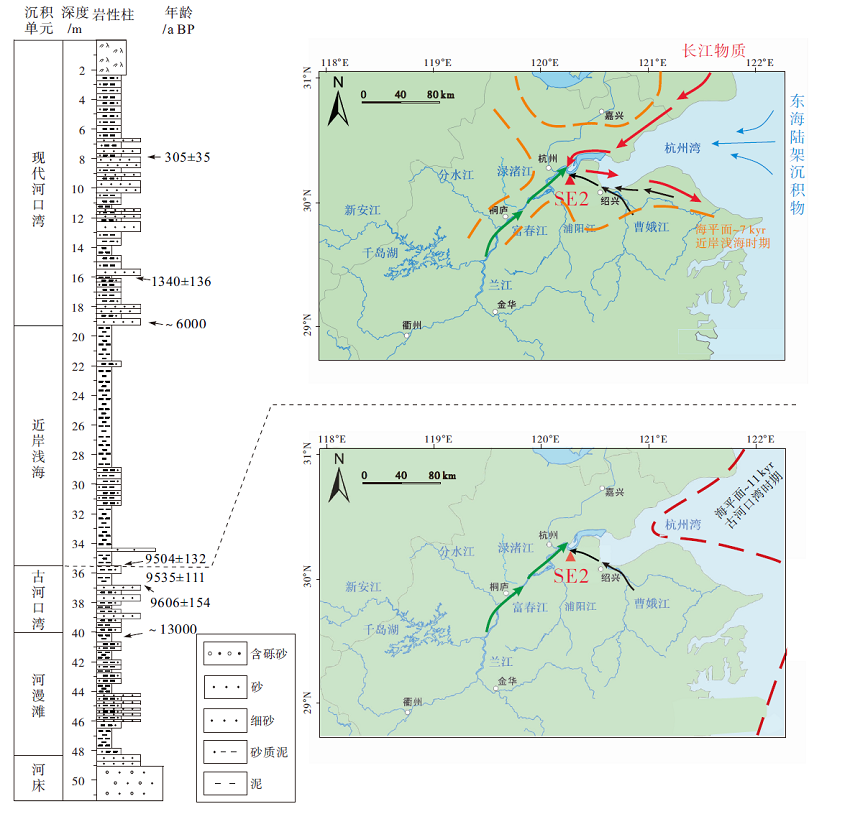
钱塘江作为中国东南部入海河流的重要一支, 不仅流域面积广、基岩岩性多样, 其入海河口紧邻泥沙含量丰富的长江河口, 潮汐作用强烈, 因此, 杭州湾地区复杂的水动力过程、沉积演化、物源供给以及对全新世气候的响应吸引了众多研究学者(张桂甲和李从先, 1995; Lin et al., 2004, 2005; Zhang et al., 2014, 2015, 2018, 2021; 席亚娟等, 2015, 2016; Liu et al., 2018)。全新世以来, 随着海平面变化, 钱塘江下切河谷经历快速充填— 埋藏的演化: (1)15.0~8.0 ka BP, 气候转暖, 海平面迅速上升, 海侵形成河漫滩— 古河口湾沉积; (2)8.0~6.0 ka BP, 海平面上升至最高值, 下切河谷形成近岸浅海; (3)6.0 ka BP至今, 海平面趋于平稳, 形成现代河口湾(Lin et al., 2005; 张霞, 2013)。长江— 钱塘江— 东海陆架组成一个世界典型的强潮型三角洲— 河口湾— 陆架源汇系统, 钱塘江下切河谷全新世充填物的沉积演化与毗邻的长江下切河谷和东海陆架密切相关(Zhang et al., 2015, 2021; 张霞等, 2018)。长江沉积物自8.0 ka BP开始大量进入钱塘江下切河谷, 其既可通过沿岸流将长江沉积物直接运送到钱塘江下切河谷内, 也可通过潮流/波浪将已沉积在口外或杭州湾北岸沉积物再悬浮和再搬运带入到钱塘江沉积体系中; 在8.0~6.0 ka BP之间, 50%的长江来源物质沉积于钱塘江下切河谷内, 形成近岸浅海沉积, 而6.0 ka BP以来, 只有不到4%的长江源沉积物进入到钱塘江下切河谷内, 形成现代河口湾沉积, 大部分长江泥质沉积物在沿岸流的作用下向南搬运, 形成长达800 km长的浙闽沿岸泥质条带(吴华林等, 2006; Zhang et al., 2015, 2021; Liu et al., 2018)。
另外, 全新世气候变化一直是地球科学研究的热点, 钱塘江流域构造稳定, 其下切河谷充填物的地球化学指标可作为古风化和古气候的指示, 特别是细粒黏土矿物组成(Xiong et al., . 2010; Bi et al., 2015; Bao et al., 2019; Ren et al., 2019), 但钱塘江下切河谷充填物中黏土矿物组成缺乏系统性研究, 且影响其分布的因素还有待考证。因此, 本研究对全新世钱塘江下切河谷充填物的黏土矿物组成进行分析, 并结合中国东南沿海7条主要入海河流的黏土矿物组合和分布特征(杨作升, 1988; 范德江等, 2001; Ma et al., 2010; 徐勇航等, 2013; 张霞, 2013; 席亚娟, 2015), 探讨了其与物源、气候以及水动力条件之间的耦合关系, 为世界相似河口区全新世沉积物中黏土矿物组成、展布规律及其控制因素等方面研究提供宝贵资料。
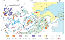
钱塘江作为中国东南部入海河流的重要一支, 是浙江省第一大河, 其流域覆盖浙江省西北部和安徽省东南部(118° ~122° E, 29° ~30° N), 处于亚热带季风气候区。钱塘江北源为新安江, 南源是兰江, 二者在建德县梅城汇合下行至闻堰, 称为富春江, 闻堰至澉浦这一段为富春江, 其与浦阳江汇合为钱塘江。河长从北源新安江起累计总长668 km, 流域面积55 558 km2(师育新和戴雪荣, 2015)。钱塘江流域覆盖面积广, 出露地层复杂(中国地质调查局, 2005; Zhang et al., 2015)。钱塘江上游新安江流经大量花岗闪长岩以及部分的花岗岩体, 而另一上游分支兰江流经晚侏罗世的中酸性火山岩和花岗岩、流纹斑岩岩体; 中汇水系富春江广泛流经晚侏罗世中酸性火山岩、分水江小面积出露石英闪长岩; 下游曹娥江流域岩性复杂, 包括晚侏罗世中酸性火山岩、基性的橄榄玄武岩、中性的石英二长岩(俞国华等, 1995); 钱塘江下游入海河口位置由大面积的第四系沉积物组成(图 1)。整体钱塘江水系流域岩体出露43%的第四系沉积物, 38%的晚侏罗世中酸性火山岩, 6%的花岗岩, 6%的花岗闪长岩, 2%的流纹斑岩, 2%的橄榄玄武岩, 1%的石英二长岩, 1%的石英闪长岩, 1%的晚侏罗世侵入岩。
 | 图 1 钱塘江流域地质图及SE2孔位置(据中国地质调查局, 2005; Zhang et al., 2015; 有修改) 图例: 1. 上白垩统; 2. 下白垩统; 3. 晚侏罗世侵入岩; 4. 晚侏罗世火山岩; 5. 三叠系; 6. 二叠系; 7. 第四系; 8. 石英二长岩; 9. 流纹岩; 10. 花岗闪长岩; 11. 安山斑岩; 12. 橄榄玄武岩; 13. 石英闪长岩; 14. 花岗岩; 15. 地名; 16. 江山— 绍兴断裂; 17. 钱塘江水系; 18. SE2孔位置Fig.1 Geological map of the Qiantang River drainage basin and location of core SE2 (modified from China Geological Survey, 2005; Zhang et al., 2015) |
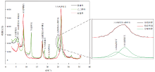
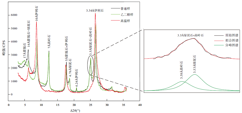 | 图 2 钱塘江下切河谷SE2孔近岸浅海相沉积物的黏土矿物XRD衍射图谱(a)与高岭石和绿泥石3.5Å 峰的Peakfit分峰拟合(b)Fig.2 XRD patterns showing characteristics of clay minerals in offshore shallow marine sediments from core SE2 in Qiantang River incised valley(a)and peak separation fitting for kaolinite and chlorite in 3.5Å peak by using Peakfit software(b) |
末次盛冰期以来钱塘江下切河谷自下而上依次发育河床复合体(含砾砂)、河漫滩(砂质泥与细砂)、古河口湾(泥质与砂质泥互层)、近岸浅海(泥夹粉砂条带)、现代河口湾(细砂及砂质泥)5个沉积单元, 整体上粒度由下至上先变细后再变粗(李从先等, 2008; 张霞, 2013; Wang et al., 2020)。现代河口湾因强潮影响, 水动力强烈、沉积物分选优良、颗粒均匀、悬移质和推移质均以粉砂为主。
钱塘江下切河谷全新世沉积物的黏土组分样品取自SE2孔的现代河口湾、近岸浅海、古河口湾和河漫滩沉积物, 前三者的取样间隔为2 m, 后者为4 m, 共计24个样品。SE2孔位于浙江省余杭— 萧山一带(120° 21'57″ E, 30° 12'38″ N), 钻孔共51.5 m长, 取心率为96%, 岩性主要有含砾砂、细砂、粉砂和泥(Zhang et al., 2014)。
实验室内黏土矿物的分析步骤为: (1)首先取约10 g样品, 先后用体积含量为30%的H2O2溶液和1 mol/L的HCl溶液与样品充分反应以去除有机质和碳酸盐, 待反应结束不再产生气泡后用去离子水清洗2次, 使样品有抗絮凝作用而充分分散; (2)抽取上部小于2 μ m的悬浮液, 离心浓缩, 每个样品制成3个自然定向片, 用乙二醇蒸汽在40~50 ℃条件下将其中一个自然定向片恒温7 h再冷却制成乙二醇饱和定向片, 并在550± 10 ℃ 条件下将另一自然定向片恒温2 h, 自然冷却至室温制成加热片; (3)采用Cu靶线光源分别对自然定向片(3° ~35.99° 2θ , 步长0.01° )、乙二醇饱和片(3° ~35.98° 2θ , 步长0.02° )和高温加热片(3° ~35.98° 2θ , 步长0.02° )进行黏土矿物X射线衍射(XRD)测试。该实验在南京大学内生金属矿床成矿机制研究国家重点实验室完成, 测试仪器为布鲁克D8 Advance系统的X射线衍射仪, 配备LYNXEYE XE-T能量色散二维阵列探测器, 工作电压为3 kV, 工作功率为1.6 kW。
黏土矿物种类的鉴定和解释主要依据3种测试条件下(自然定向片、乙二醇饱和片和高温片)获得的XRD叠加图谱进行综合对比。在自然定向片的XRD图谱中, 伊利石的特征衍射峰为10 Å 和5 Å , 高岭石和绿泥石的特征衍射峰基本重合, 为7 Å 和3.5 Å , 蒙脱石的特征峰为15 Å 。乙二醇饱和对伊利石、高岭石和绿泥石基本无影响, 但会使蒙脱石膨胀, 致使其衍射峰从15 Å 增加至17 Å 。加热条件下, 高岭石结构被破坏, 致使衍射峰3.58 Å 消失, 而绿泥石的结构可能被破坏导致3.53 Å 衍射峰强度降低(靳华龙等, 2019)。本次研究主要依据Biscaye(1965)提出的方法计算各类黏土矿物的相对含量, 公式中所涉及波峰参数的半定量计算使用JADE6.0软件在乙二醇饱和样品的XRD衍射曲线上进行扣背景、寻峰等确定。由于高岭石和绿泥石特征峰非常接近, 难以区分, 故在使用Biscaye(1965)方法所获得的基础上, 对3.5 Å 左右的高岭石和绿泥石峰采用Peakfit软件进行分峰拟合来确定两者的相对含量。其次, 采用5 Å 与10 Å 的峰面积比值来表示伊利石的化学风化指数, 10 Å 峰的半高宽表示伊利石结晶度(KI指数, Kubler, 1964)。伊利石主峰越尖锐, 结晶程度越好, 因此, 结晶度与KI指数呈反比。
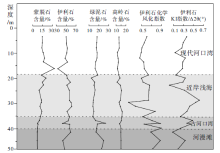
SE2孔全新世沉积物黏土矿物主要由伊利石(I)、绿泥石(Chl)、高岭石(Kao)和蒙脱石(S)组成, 未识别出蛭石。伊利石含量为40.89%~68.84%, 平均59.99%, 最高值出现在近岸浅海, 垂向上由深到浅整体表现为先递增, 近岸浅海开始递减; 绿泥石含量为7.72%~35.54%, 平均17.52%, 垂向上由深到浅整体表现为先递减再递增, 在古河口湾和近岸浅海的界限附近呈现陡的递减, 近岸浅海开始递增; 高岭石含量为9.00%~18.74%, 均值14.23%, 垂向上由深到浅表现为先递增再递减, 近岸浅海开始递减; 蒙脱石含量为0%~33.86%, 平均8.26%, 其含量在纵向上变化最为明显, 从底部的河漫滩至顶部的河口湾呈现明显递增趋势(表 1; 图 3)。河漫滩与近岸浅海相之间, 各黏土矿物组成发生明显的转变。在河口湾16.1 m处黏土矿物组成出现异常, 表现为蒙脱石含量突增至33.86%, 而伊利石含量降低至40.89%, 绿泥石和高岭石的含量与纵向上变化不明显, 分别为15.03%和10.22%。由于伊利石和蒙脱石粒度偏小, 容易在水动力弱的条件下沉积, 河口地区含量较少, 相反绿泥石粒度最大, 容易在河口部位等水动力条件较强地方沉积。前人研究显示, 东海外部陆架沉积中心黏土矿物中蒙脱石的分布较高, 可高达18%, 而伊利石的含量约50%(Zhao et al., 2018)。因此, SE2钻孔距地面16.1 m深处的蒙脱石与伊利石的异常分布可能为事件沉积导致, 将东海陆架甚至更远处的黏土矿物带至钱塘江河口湾沉积。
| 表 1 钱塘江下切河谷SE2孔全新世沉积物黏土矿物组成特征 Table1 Clay mineral composition of the Holocene sediments from core SE2 in Qiantang River incised valley |
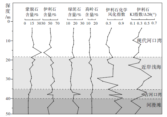 | 图 3 钱塘江下切河谷SE2孔全新世沉积物黏土矿物含量垂向变化特征Fig.3 Vertical variation trend of contents for clay mineral from sediments of core SE2 in Qiantang River incised valley |
钱塘江下切河谷充填物中的伊利石KI指数在纵向上由深到浅表现为递增— 递减— 递增的趋势, 最顶部的现代河口湾为伊利石KI指数的相对低值区。研究区伊利石KI指数的变化范围为0.13° ~0.72° Δ 2θ , 平均为0.42° Δ 2θ 。约一半样品的伊利石KI指数小于0.4° Δ 2θ , 主要分布在现代河口湾, 其次为近岸浅海, 表明现代河口湾的伊利石结晶度极好, 所遭受的大陆源区的水解作用较弱(刘志飞等, 2007)。伊利石化学风化指数的变化范围为0.32~0.96, 纵向上整体表现为递减— 递增, 大多数伊利石化学风化指数大于0.50, 而小于0.50的低值区主要分布在现代河口湾, 由此可见, 研究区的黏土矿物主要为源区物质遭受化学风化蚀变而成。
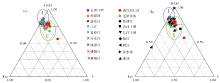
SE2孔全新统埋藏较浅, 成岩作用较弱, 黏土矿物间相互转化不明显, 因此黏土矿物组合基本可反映物质来源。研究发现SE2孔河漫滩和古河口湾沉积物中黏土矿物组成表现为: 伊利石+绿泥石含量大于75%, 蒙脱石含量小于10%, 高岭石含量大于15%; 而近岸浅海和现代河口湾沉积物中黏土矿物组成表现为: 伊利石+绿泥石含量小于75%, 蒙脱石含量大于10%, 高岭石含量大于10%; 根据黏土矿物分布可将Ⅰ 段(河漫滩和古河口湾沉积物)和Ⅱ 段(现代河口湾和近岸浅海沉积物)明显区分开(图 4)。Ⅰ 段中的黏土矿物组成与河口外的中国东南部入海河流的黏土矿物分布相似性不大, 而与现代钱塘江干流和主要支流沉积物的黏土矿物组成相似(图 4-a), 表明该时期钱塘江下切河谷沉积物主要由钱塘江上游提供。这是因为该时期虽然海平面从现今海平面之下110~120 m逐渐上升至现今海平面之下30 m(Liu et al., 2004), 但海岸线仍远离现今海岸线, 长江和钱塘江下切河谷仍然彼此分离, 古长江沉积物主要局限于其下切河谷内, 未进入钱塘江下切河谷(图 6; Liu et al., 2007; 张霞, 2013; zhang et al., 2014, 2015)。然而Ⅱ 段沉积物中的黏土矿物组成与长江下游更为相似(图 4-b), 表明该时期海平面的极速上升已淹没钱塘江和长江下切河谷, 两者相互连通, 河口外长江物质因潮流、波浪、风暴潮、环流等剥蚀搬运而进入到钱塘江下切河谷中(图 5), 这与前人通过重矿物、元素地球化学和锆石U-Pb测年分析结果一致(张霞等, 2018; Zhang et al., 2021)。
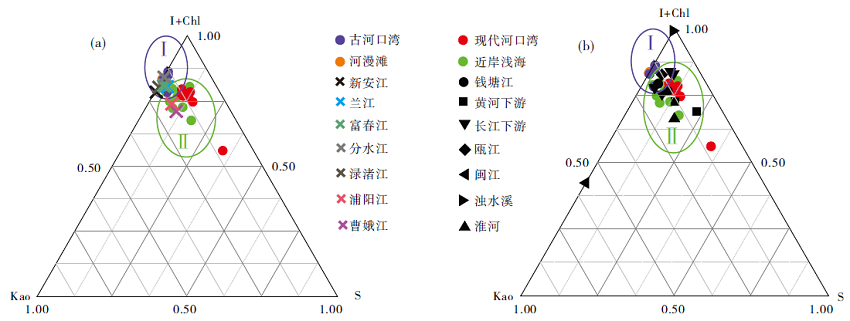 | 图 4 钱塘江下切河谷SE2孔黏土矿物与钱塘江流域黏土矿物对比(a)(钱塘江流域数据来自席亚娟, 2015)以及与河口外黏土矿物的对比(b)(河口外数据来自杨作升, 1988; Xu, 1983; 范德江等, 2001; Xu et al., 2009; 张军强等, 2011; Xu et al., 2012; He et al., 2013; Wang et al., 2013; 梁小龙等, 2015)Fig.4 Comparison of clay-mineral component between Qiantang River incised-valley fill and sediments from Qiantang River drainage area(a)(Data about the Qiantang River drainage area after Xi, 2015), and sediments of main rivers outside Qiantang River estuary(b)(data about the main rivers outside Qiantang River estuary after Yang, 1988; Xu, 1983; Fan et al., 2001; Xu et al., 2009; Zhang et al., 2011; Xu et al., 2012; He et al., 2013; Wang et al., 2013; Liang et al., 2015) |
 | 图 5 钱塘江下切河谷SE2孔物源搬运模式(改自Zhang et al., 2021)Fig.5 Model of sediment transportation in Qiantang River incised valley(modified from Zhang et al., 2021) |
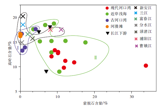 | 图 6 钱塘江流域表层沉积物与钱塘江下切河谷充填物的高岭石和蒙脱石含量对比Fig.6 Plot showing difference of kaolinite and smectite contents between sediments from Qiantang River drainage area and incised-valley fill |
绿泥石和伊利石含量研究层段变化不大, 不能用来区分物源, 而蒙脱石和高岭石的含量变化可较好地指示钱塘江下切河谷充填物黏土矿物来源(图 6)。高岭石含量自钱塘江流域表层河流向下切河谷呈现递减趋势, 钱塘江流域上游两大支流新安江和兰江的高岭石最高, 下切河谷Ⅰ 段(河漫滩和古河口湾沉积物)高岭石含量最低, 因此下切河谷的高岭石主要来源于钱塘江流域。而在Ⅱ 段(现代河口湾以及近岸浅海), 高岭石递减的趋势下还有明显的蒙脱石含量的增加, 此时海平面上升至钱塘江河口湾, 长江和钱塘江下切河谷相互连通, 沿岸流作用增强, 钱塘江下切河谷混入外来长江物质, 因此可以推测钱塘江下切河谷Ⅱ 段的蒙脱石主要由长江物质提供。
钱塘江流域基岩类型主要为花岗岩、花岗闪长岩、正长岩以及少量基性橄榄玄武岩, 这些岩石中含有大量的长石、云母等铝硅酸盐矿物, 其在干冷环境下弱淋滤脱K形成大量的伊利石, 或在温暖潮湿的环境下K+完全淋失形成高岭石; 而岩石中的少量的辉石、角闪石以及黑云母等则为绿泥石提供了物质基础(汤艳杰等, 2002; Fagel et al., 2003)。并且, 除曹娥江和浦阳江以外, 流域基岩为中酸性、富K+、贫Na+和Ca2+, 因此蒙脱石不易形成(Griffin et al., 1968)。而长江流域跨越多个造山带, 大面积分布碳酸盐岩、陆源碎屑岩、以及中酸性侵入岩、片麻岩等, 特别是长江流经世界著名的峨眉山大火成岩省(何梦颖等, 2011), 碱性、潮湿、贫K+、富Na+和Ca2+环境下的大面积基性火山岩或火山灰为蒙脱石的形成提供了物质和环境条件。
此外, 图 4-b中可见现代河口湾和近岸浅海沉积物中黏土矿物分布与黄河下游的黏土矿物分布也有相似性, 主要体现在蒙脱石含量明显增加至12%左右, 但研究表明黄河沉积最多到达(123° E, 32° N)的位置, 因此处于(122° E, 30° N)位置的钱塘江河口湾很难有黄河物质的进入(范德江等, 2002; Shi et al., 2015; Liu et al., 2018)。但也可能是苏北地区的老黄河沉积物给钱塘江下切河谷提供了部分物源, 有待进一步研究。
气候不仅对黏土矿物成分含量产生影响, 在矿物结晶学特征上也有较好显示。伊利石结晶度受温度、压力、时间和颗粒大小等因素影响, 其中受温度影响最大, 温度越高, 气候越温暖潮湿, 化学风化越强, 伊利石结晶度越差, KI指数越大(文宝萍等, 2008; 万琳琪, 2020)。前人认为, 伊利石化学风化指数可以用来确定风化作用类型, 数值大于0.50指示强烈水解作用, 即以化学风化为主, 伊利石化学风化指数越高, 指示古气候越湿热(Gingele et al., 2001)。如图 7-a所示, 研究区伊利石化学风化指数的变化范围为0.32~0.96, 一般大于0.50, 而小于0.50的低值区分布在现代河口湾, 由此可见, 研究区的黏土矿物主要为源区化学风化蚀变而成。由于河漫滩、古河口湾的伊利石化学风化指数高于现代河口湾和近岸浅海, 前者化学风化更为强烈, 而现代河口湾以及近岸浅海沉积时期化学风化相对较弱。整体上, 伊利石化学风化指数与伊利石KI指数呈现负相关, 与伊利石结晶度呈现正相关关系, 拟合直线相关系数为0.04, 伊利石化学指数越高, 伊利石结晶度越高(数值越低), 说明伊利石水解越弱, 反之亦然。物源区的长石、云母等铝硅酸盐矿物风化形成伊利石, 风化加强时, 伊利石进一步转化为蒙脱石或者高岭石, 因此破坏了伊利石的晶体结构从而导致伊利石的结晶度下降(参考Liu et al., 2007), 显然理论上伊利石风化指数和结晶度之间呈现负相关关系, 与本次研究中的情况相反, 造成这种现象的原因可能是未区分开的长江物源和钱塘江物源的沉积颗粒具有不同的风化程度和结晶度。如果将两者分开讨论时, 考虑到仅河漫滩相沉积物物源单一, 仅为钱塘江流域提供, 其伊利石化学风化指数与结晶度之间呈现较好的负相关, 相关系数为0.94。因此, 在使用伊利石结晶度来反映化学风化强度, 进而讨论气候变化时, 一定要考虑沉积物物源演化对其的影响, 即在利用该相关性图时需考虑到泥沙来源的复杂性。
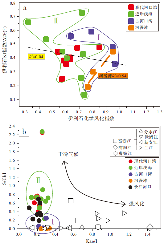 | 图 7 黏土矿物气候指标: (a)伊利石化学风化指数与KI指数相关性; (b)Kao/I与S/Chl相关图Fig.7 Climate indices based on clay-mineral assemblages: (a)correlation between illite chemical index and illite KI index; (b)Kao/I vs. S/Chl plot |
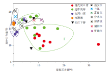
高岭石主要形成于温暖、潮湿的热带土壤环境, 对应强淋滤、强风化的湿润条件; 与高岭石的分布相反, 绿泥石则主要来自火成岩和变质岩的风化, 在寒冷、干燥的环境中富集; 伊利石与绿泥石类似, 而蒙脱石主要富集在半干旱环境(Gingele, 1996)。S/Chl和Kao/I 指标对通过追踪流域泥沙来源重建环境变化具有一定的指导意义, 可以全面说明各影响因素相关的差异。在干冷气候条件下, 随着风化加强, 蒙脱石可以转变为蒙脱石— 绿泥石的混层, 伊利石可以转化为高岭石, 因此, 高S/Chl值指示干冷的气候条件, 高Kao/I值指示强风化(Ma et al., 2010)。图 7-b中, 从河漫滩和古河口湾至现代河口湾和近岸浅海, Kao/I值无明显变化, 而S/Chl值明显增高, 且长江河口的S/Chl值位于Ⅰ 段和Ⅱ 段之间。由于蒙脱石的含量受物源影响, 而绿泥石的分布受水动力影响较大, 作者认为从河漫滩和古河口湾至现代河口湾和近岸浅海显著增高的S/Chl值, 可能与Ⅱ 段沉积时期长江沉积物的大量输入, 以及近岸浅海时期的高海平面和较弱水动力条件有关, 并不能很好地反映气候变化。长江中下游地区早全新世(11.7~8.2 ka BP)气候由干冷转为温和湿润, 中全新世(8.2~4.2 ka BP)气候最为湿热, 在6.0 ka BP以后, 气候波动强烈, 且气温逐渐回落, 晚全新世(4.2 ka BP 至今)时期气候接近现今(周子康和刘为纶, 1996; 萧家仪等, 2004)。尽管Kao/I变化微弱, 但是仍可见(图 7-b):
(1)古河口湾— 近岸浅海时期(~13.0~6.0 ka BP), 长江物源混入以及气候变化共同影响高岭石和伊利石分布, 2种因素相互作用, 使得Kao/I无明显连续变化, 但在近岸浅海时期(~9.0~6.0 ka BP), Kao/I值和高岭石含量均达到整个下切河谷的最高值(图 3), 较好地对应了最为湿热的中全新世; (2)近岸浅海— 现代河口湾(~8.0 ka BP至今), Kao/I值明显降低、风化减弱, 高岭石含量也逐渐降低, 表明气候逐渐回冷(图 3; 图 7-b)。因此综合多种黏土矿物的气候指标后, 认为在杭州湾地区, 因复杂的物源、强烈的水动力影响, 高岭石可能是一个相对较好的气候指标。
1)钱塘江下切河谷内SE2孔沉积物的黏土矿物由伊利石(I)、绿泥石(Chl)、高岭石(Kao)和蒙脱石(S)组成, 未识别出蛭石, 均值分别为59.99%、17.52%、14.23%和8.26%。整体上从底部的河漫滩至顶部的现代河口湾, 蒙脱石含量呈现增加趋势, 伊利石和高岭石含量呈先递增再递减趋势, 而绿泥石含量先递减再递增。河漫滩与近岸浅海之间, 各黏土矿物组成发生明显的转变。
2)钱塘江下切河谷内SE2孔沉积物黏土矿物组成的控制因素主要为物源, 古河口湾和河漫滩沉积物含较多高岭石, 指示物源主要以钱塘江上游为主, 河口外物质贡献不大, 而现代河口湾和近岸浅海沉积物含较多蒙脱石, 表明物源不仅包括钱塘江上游, 河口外的长江物质也在沿岸流和涨潮的环境下带入钱塘江河口沉积。
3)在复杂物源、强烈水动力影响下的杭州湾地区, 高岭石可能是一个相对较好的气候指标。中全新世气候最为湿热, 高岭石含量最高, 化学风化程度较高; 晚全新世高岭石含量逐渐降低, 化学风化程度也减低, 气候逐渐回冷。
致谢 南京大学地球科学与工程学院蔡元峰老师给予黏土矿物半定量分析方面帮助, 赵思狄同学给予图件绘制方面帮助, 2位匿名审稿专家提出了建设性修改意见, 在此一并向他们致以衷心的感谢!
(责任编辑 李新坡; 英文审校 徐 杰)
| [1] |
|
| [2] |
|
| [3] |
|
| [4] |
|
| [5] |
|
| [6] |
|
| [7] |
|
| [8] |
|
| [9] |
|
| [10] |
|
| [11] |
|
| [12] |
|
| [13] |
|
| [14] |
|
| [15] |
|
| [16] |
|
| [17] |
|
| [18] |
|
| [19] |
|
| [20] |
|
| [21] |
|
| [22] |
|
| [23] |
|
| [24] |
|
| [25] |
|
| [26] |
|
| [27] |
|
| [28] |
|
| [29] |
|
| [30] |
|
| [31] |
|
| [32] |
|
| [33] |
|
| [34] |
|
| [35] |
|
| [36] |
|
| [37] |
|
| [38] |
|
| [39] |
|
| [40] |
|
| [41] |
|
| [42] |
|
| [43] |
|
| [44] |
|
| [45] |
|
| [46] |
|
| [47] |
|
| [48] |
|
| [49] |
|
| [50] |
|
| [51] |
|
| [52] |
|
| [53] |
|
| [54] |
|
| [55] |
|
| [56] |
|
| [57] |
|
| [58] |
|
| [59] |
|